Wellingsbüttel
| Dzielnica Hamburga | |||
 | |||
| |||
| Państwo | |||
|---|---|---|---|
| Miasto | |||
| Okręg administracyjny | |||
| W granicach Hamburga | 1 kwietnia 1938 | ||
| Powierzchnia | 4,10 km² | ||
| Wysokość | 28 m n.p.m. | ||
| Populacja (31 grudnia 2011) • liczba ludności |
| ||
| • gęstość | 2 479 os./km² | ||
| Strefa numeracyjna | 040 | ||
| Kod pocztowy | 22391 | ||
| Tablice rejestracyjne | HH | ||
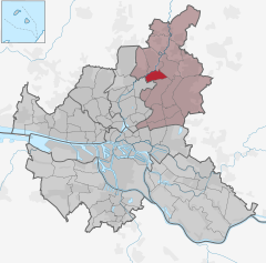
Położenie na mapie Hamburga | |||
| 53°38′28″N 10°04′47″E/53,641111 10,079722 | |||
| Portal | |||
Wellingsbüttel, Hamburg-Wellingsbüttel – dzielnica miasta Hamburg w Niemczech, w okręgu administracyjnym Wandsbek.
1 kwietnia 1938 na mocy ustawy o Wielkim Hamburgu włączony w granice miasta.
Bibliografia
- Statistisches Amt für Hamburg und Schleswig-Holstein, Hamburg
Media użyte na tej stronie
Autor: TUBS
Location of borough xy (see filename) in Hamburg.
Wappen des Hamburger Stadtteils Wellingsbuettel.
Autor: Claus-Joachim Dickow, Licencja: CC BY-SA 3.0
Alte Volksschule des damals stormarnischen Dorfes Wellingsbüttel von 1888. Von 1946 bis 1974 wurde das Gebäude von der Peter-Petersen-Schule genutzt. Jetzt sind eine Sozialstation, ein Kindergarten und eine Zweigstelle der Hamburger Öffentlichen Bücherhallen in dem Gebäude untergebracht.
It is on the list of cultural monuments of Hamburg, no. 1260
Historical Coat of arms of Wandsbek - The shield with the swan is the arms of the Stormarn territory, the other elements refer to the famous Wandsbeck Messenger, Mathias Claudius (1740-1815).


