Wentworth Falls
| ||
 | ||
| Kontynent | Australia | |
|---|---|---|
| Państwo | ||
| Stan | ||
| Wysokość | 187 m | |
| Rzeka zasilająca | Kedumba Creek | |
| 33,7272°S 150,3740°E/-33,727200 150,374000 | ||
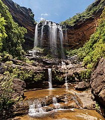
Wentworth Falls – wodospad sezonowy położony w Australii (Nowa Południowa Walia), w parku narodowym Blue Mountains, na rzece Kedumba Creek, wysokości 187 metrów.
U podnóży wodospadów znajduje się jedno z dwóch miejsc występowania endemicznego dla Gór Błękitnych krzewu iglastego – Pherosphaera fitzgeraldii[1].
Przypisy
- ↑ Aljos Farjon, Denis Filer: An Atlas of the World’s Conifers. An Analysis of their Distribution, Biogeography, Diversity and Conservation Status. Leiden, Boston: BRILL, 2013, s. 365. ISBN 978-90-04-21180-3.
Media użyte na tej stronie
Autor: , Licencja: CC BY-SA 3.0
Relief map of Australia, including the borders of the states of the Commonwealth of Australia
Autor: Tentotwo, Licencja: CC BY-SA 3.0
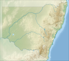
Relief location map of New South Wales, Australia Equidistant cylindrical projection, latitude of true scale 32.82° S (equivalent to equirectangular projection with N/S stretching 119 %). Geographic limits of the map:
- N: 27.9° S
- S: 37.8° S
- W: 140.6° E
- E: 153.9° E
Autor: Diliff, Licencja: CC BY-SA 3.0
Upper Wentworth Falls as viewed along the National Pass walking track in the Jamison Valley, near the town of Wentworth Falls in the Blue Mountains, Australia.
Shiny LightSteelBlue button/marker widget. Used to mark the location of something such as a tourist attraction.


