West Acton
 Budynek stacji West Acton, 2008 | |
| Państwo | |
|---|---|
| Miejscowość | Londyn |
| Dzielnica | Acton |
| Data otwarcia | 1923 |
| Liczba peronów | 2 |
| Central Line | |
| Poprzednia stacja | Ealing Broadway |
| Następna stacja | North Acton |
Położenie na mapie gminy Ealing  Contains Ordnance Survey data © Crown copyright and database right, CC BY-SA 3.0 | |
Położenie na mapie Wielkiej Brytanii  (c) Karte: NordNordWest, Lizenz: Creative Commons by-sa-3.0 de | |
Położenie na mapie Anglii  | |
Położenie na mapie Wielkiego Londynu  Contains Ordnance Survey data © Crown copyright and database right, CC BY-SA 3.0 | |
| Portal | |
West Acton – stacja londyńskiego metra położona w północno-zachodniej części miasta, na trasie Central Line pomiędzy stacjami Ealing Broadway a North Acton. Znajduje się w dzielnicy Acton w gminie London Borough of Ealing, w trzeciej strefie biletowej[1], niedaleko stacji North Ealing, obsługiwanej przez Piccadilly line.
26 lipca 2011 roku budynek stacji został wpisany na listę obiektów zabytkowych[2].
Galeria
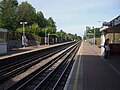
Widok na wschód

Widok na zachód
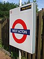
Symbol stacji
Przypisy
- ↑ Tube stations - West Acton (ang.). Transport For London. [dostęp 2012-01-08].
- ↑ 16 London Underground Stations Listed At Grade II (ang.). English Heritage. [dostęp 2012-01-08].
| Linia główna | |
|---|---|
| Odgałęzienie West Ruislip | |
| Odgałęzienie Ealing Broadway | |
| Odgałęzienie Woodford | |
| Odgałęzienie Epping |
![]()
Media użyte na tej stronie
(c) Karte: NordNordWest, Lizenz: Creative Commons by-sa-3.0 de
Location map of the United Kingdom
Contains Ordnance Survey data © Crown copyright and database right, CC BY-SA 3.0
Map of Greater London, UK with the following information shown:
- Administrative borders
- Coastline, lakes and rivers
- Roads and railways
- Urban areas
The data includes both primary routes and railway lines.
Equirectangular map projection on WGS 84 datum, with N/S stretched 160%
Geographic limits:
- West: 0.57W
- East: 0.37E
- North: 51.72N
- South: 51.25N


Contains Ordnance Survey data © Crown copyright and database right, CC BY-SA 3.0
Blank map of the London Borough of Ealing, showing electoral wards used from 2002 to 2022.
Equirectangular map projection on WGS 84 datum, with N/S stretched 160%
Geographic limits:
- West: 0.425W
- East: 0.24W
- North: 51.565N
- South: 51.485N

Autor: Sunil060902, Licencja: CC BY-SA 3.0
West Acton tube station looking east

Autor: Sunil060902, Licencja: CC BY-SA 3.0
West Acton tube station looking west

Autor: Sunil060902, Licencja: CC BY-SA 3.0
West Acton tube station platform roundel