West Kensington (stacja metra)
| ||
 Wejście na stację | ||
| Państwo | ||
| Kraj | ||
| Miejscowość | Londyn | |
| Data otwarcia | 1874 | |
| District Line | ||
| Poprzednia stacja | Earl’s Court | |
| Następna stacja | Barons Court | |
Położenie na mapie gminy Hammersmith and Fulham  Contains Ordnance Survey data © Crown copyright and database right, CC BY-SA 3.0 | ||
Położenie na mapie Wielkiej Brytanii  (c) Karte: NordNordWest, Lizenz: Creative Commons by-sa-3.0 de | ||
Położenie na mapie Anglii  | ||
Położenie na mapie Wielkiego Londynu  Contains Ordnance Survey data © Crown copyright and database right, CC BY-SA 3.0 | ||
| Portal | ||
West Kensington - stacja metra londyńskiego na terenie London Borough of Hammersmith and Fulham, leżąca na trasie District Line[1]. Została oddana do użytku w 1874 roku[2]. W roku 2007 skorzystało z niej ok. 4,838 mln pasażerów[3]. Należy do drugiej strefy biletowej[4].
Galeria

Logo stacji
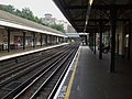
Perony
Przypisy
- ↑ Schemat sieci metra w Londynie [dostęp 2010-12-18]
- ↑ CULG - District Line. [dostęp 2010-12-18].
- ↑ Tube performance | Transport for London. [dostęp 2010-12-18].
- ↑ Lista stacji i stref biletowych metra londyńskiego [dostęp 2010-12-18]
| |||||||||||||||||||||
Media użyte na tej stronie
United Kingdom adm location map.svg
(c) Karte: NordNordWest, Lizenz: Creative Commons by-sa-3.0 de
Location map of the United Kingdom
(c) Karte: NordNordWest, Lizenz: Creative Commons by-sa-3.0 de
Location map of the United Kingdom


Flag of England.svg
Flag of England. Saint George's cross (a red cross on a white background), used as the Flag of England, the Italian city of Genoa and various other places.
Flag of England. Saint George's cross (a red cross on a white background), used as the Flag of England, the Italian city of Genoa and various other places.

West Kensington stn look east.JPG
Autor: Sunil060902, Licencja: CC BY-SA 3.0
West Kensington tube station looking east with the access to Lillie Bridge depot diverging left. It then flies over the main line towards the depot.
Autor: Sunil060902, Licencja: CC BY-SA 3.0
West Kensington tube station looking east with the access to Lillie Bridge depot diverging left. It then flies over the main line towards the depot.

West Kensington stn roundel.JPG
Autor: Sunil060902, Licencja: CC BY-SA 3.0
West Kensington tube station platform roundel
Autor: Sunil060902, Licencja: CC BY-SA 3.0
West Kensington tube station platform roundel
Greater London UK location map 2.svg
Contains Ordnance Survey data © Crown copyright and database right, CC BY-SA 3.0
Contains Ordnance Survey data © Crown copyright and database right, CC BY-SA 3.0
Map of Greater London, UK with the following information shown:
- Administrative borders
- Coastline, lakes and rivers
- Roads and railways
- Urban areas
The data includes both primary routes and railway lines.
Equirectangular map projection on WGS 84 datum, with N/S stretched 160%
Geographic limits:
- West: 0.57W
- East: 0.37E
- North: 51.72N
- South: 51.25N

Hammersmith and Fulham London UK blank ward map.svg
Contains Ordnance Survey data © Crown copyright and database right, CC BY-SA 3.0
Contains Ordnance Survey data © Crown copyright and database right, CC BY-SA 3.0
Blank map of the London Borough of Hammersmith and Fulham, showing electoral wards.
Equirectangular map projection on WGS 84 datum, with N/S stretched 160%
Geographic limits:
- West: 0.26W
- East: 0.17W
- North: 51.54N
- South: 51.46N