West Oxfordshire
| ||
| dystrykt niemetropolitalny | ||
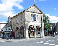
(c) Betty Longbottom, CC BY-SA 2.0 Witney | ||
| Państwo | ||
|---|---|---|
| Kraj | ||
| Region | South East England | |
| Hrabstwo | Oxfordshire | |
| Siedziba | Witney | |
| Powierzchnia | 714,4 km² | |
| Populacja (2011) • liczba ludności | 105 400 | |
| • gęstość | 150 os./km² | |
| Położenie na mapie Oxfordshire Contains Ordnance Survey data © Crown copyright and database right, CC BY-SA 3.0 | ||
| Strona internetowa | ||
| Portal | ||
West Oxfordshire – dystrykt w hrabstwie Oxfordshire w Anglii.
Miasta
Inne miejscowości
Alvescot, Ascott Earl, Ascott d’Oyley, Ascott-under-Wychwood, Asthall, Aston, Bampton, Black Bourton, Bladon, Bould, Brighthampton, Brize Norton, Broadwell, Broughton Poggs, Cassington, Chadlington, Chastleton, Chimney, Church Hanborough, Churchill, Clanfield, Cogges, Combe, Cornwell, Crawley, Curbridge, Ducklington, Enstone, Eynsham, Fifield, Filkins, Finstock, Freeland, Fulbrook, Glympton, Great Rollright, Great Tew, Hailey, Hardwick, Heythrop, Holwell, Idbury, Kelmscott, Kencot, Kiddington, Kingham, Langford, Leafield, Lew, Little Faringdon, Little Tew, Long Hanborough, Lyneham, Milton-under-Wychwood, Minster Lovell, North Leigh, Northmoor, Radford, Ramsden, Rousham, Salford, Sarsden, Shifford, Shilton, Shipton-under-Wychwood, South Leigh, Spelsbury, Standlake, Stanton Harcourt, Steeple Barton, Stonesfield, Swerford, Swinbrook, Swinbrook and Widford, Tackley, Taynton, Weald, Westwell, Widford, Wootton, Yelford.
Media użyte na tej stronie
Flag of England. Saint George's cross (a red cross on a white background), used as the Flag of England, the Italian city of Genoa and various other places.
Contains Ordnance Survey data © Crown copyright and database right, CC BY-SA 3.0
Map of Oxfordshire, UK with West Oxfordshire highlighted.
Equirectangular map projection on WGS 84 datum, with N/S stretched 160%(c) Betty Longbottom, CC BY-SA 2.0
Town Hall, Market Square, Witney, Oxfordshire


