West Ruislip
 | |
| Państwo | |
|---|---|
| Miejscowość | Londyn |
| Dzielnica | Ruislip |
| Data otwarcia | 1906 |
| Liczba peronów | 4 |
| Central Line | |
| Następna stacja | Ruislip Gardens |
| Chiltern Railways (Londyn-Birmingham) | |
| Poprzednia stacja | Denham |
| Następna stacja | South Ruislip |
Położenie na mapie gminy Hillingdon  Contains Ordnance Survey data © Crown copyright and database right, CC BY-SA 3.0 | |
Położenie na mapie Wielkiej Brytanii  (c) Karte: NordNordWest, Lizenz: Creative Commons by-sa-3.0 de | |
Położenie na mapie Anglii  | |
Położenie na mapie Wielkiego Londynu  Contains Ordnance Survey data © Crown copyright and database right, CC BY-SA 3.0 | |
| Portal | |
West Ruislip – stacja kolejowa i metra znajdująca się w zachodniej części Londynu. Obsługiwana jest przez National Rail i Central Line na niezależnych platformach. Stanowi zachodnią stację końcową Central Line poprzedzoną stacją Ruislip Gardens w kierunku centrum miasta. Połączenia National Rail obsługiwane są przez brytyjskiego przewoźnika Chiltern Railways[1].
Połączenia
Stację obsługują autobusy linii U1 i U10
Galeria
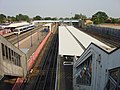
Stacja, widok z góry

Platforma Central Line w kierunku wschodnim

Platforma Chiltern Railways w kierunku wschodnim
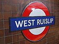
Symbol stacji
Przypisy
- ↑ Tube stations - West Ruislip (ang.). Transport for London. [dostęp 2012-01-05].
| Linia główna | |
|---|---|
| Odgałęzienie West Ruislip | |
| Odgałęzienie Ealing Broadway | |
| Odgałęzienie Woodford | |
| Odgałęzienie Epping |
![]()
Media użyte na tej stronie
(c) Karte: NordNordWest, Lizenz: Creative Commons by-sa-3.0 de
Location map of the United Kingdom
Contains Ordnance Survey data © Crown copyright and database right, CC BY-SA 3.0
Map of Greater London, UK with the following information shown:
- Administrative borders
- Coastline, lakes and rivers
- Roads and railways
- Urban areas
The data includes both primary routes and railway lines.
Equirectangular map projection on WGS 84 datum, with N/S stretched 160%
Geographic limits:
- West: 0.57W
- East: 0.37E
- North: 51.72N
- South: 51.25N


Autor: Sunil060902, Licencja: CC BY-SA 3.0
West Ruislip station, served both by London Underground and Chiltern Railways

Autor: Sunil060902, Licencja: CC BY-SA 3.0
West Ruislip station Chiltern Railways platforms looking east. Note centre fast track.

Autor: Sunil060902, Licencja: CC BY-SA 3.0
West Ruislip station terminating Central line island platform looking east, towards London, with the Chiltern Railway platforms on the left.

Contains Ordnance Survey data © Crown copyright and database right, CC BY-SA 3.0
Blank map of the London Borough of Hillingdon, showing electoral wards.
Equirectangular map projection on WGS 84 datum, with N/S stretched 160%
Geographic limits:
- West: 0.53W
- East: 0.33W
- North: 51.64N
- South: 51.45N

Autor: Sunil060902, Licencja: CC BY-SA 3.0
Roundel on Central line terminating platforms at West Ruislip station