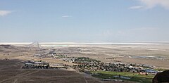
West Wendover
| ||
 | ||
| Państwo | ||
| Stan | ||
| Hrabstwo | Elko | |
| Kod statystyczny | FIPS: 32-83730 | |
| Burmistrz | Emily Carter | |
| Powierzchnia | 19,4 km² | |
| Wysokość | 1360 m n.p.m. | |
| Populacja (2010) • liczba ludności • gęstość | 4 410[1] 243,2 os./km² | |
| Nr kierunkowy | 775 | |
| Kod pocztowy | 89883 | |
| Strefa czasowa | UTC-07:00 UTC-06:00 | |
| Strona internetowa | ||
| Portal | ||
West Wendover – miasto w hrabstwie Elko stanu Nevada. W roku 2000 liczba mieszkańców wyniosła 4 721.
Granica West Wendover znajduje się na granicy stanowej i fizycznie, jest połączone z Wendover na terenie Utah. Przez oba miasta przechodzi Autostrada Międzystanowa nr 80. Nevada znajduje się w strefie czasowej Pacific. Jednak ze względu na ekonomiczną więź z Utah, Amerykański Departament Transportu w październiku 1999 roku przeniósł West Wendover do strefy czasowej Mountain.
West Wendover dzięki położeniu w Nevadzie, gdzie jest dozwolony hazard, czerpał z niego dochody. Tymczasem Wendover położony w Utah chylił się ku upadkowi. Mieszkańcy obu miast postanowili zaanektować Wendover do Nevady, uważając, że są jedną społecznością niesłusznie podzieloną. Rządy obu stanów poparły ten pomysł, jednakże dokładne szczegóły aneksji nie zostały ustalone. Granicę stanową może zmienić tylko Kongres Stanów Zjednoczonych.
Geografia
Całe miasto zajmuje 19,4 km² (7,5 mi²).
Linki zewnętrzne
Przypisy
| ||||||||||||||
Media użyte na tej stronie
Autor: Uwe Dedering, Licencja: CC BY-SA 3.0
Location map of the USA (without Hawaii and Alaska).
EquiDistantConicProjection:
Central parallel:
* N: 37.0° N
Central meridian:
* E: 96.0° W
Standard parallels:
* 1: 32.0° N
* 2: 42.0° N
Made with Natural Earth. Free vector and raster map data @ naturalearthdata.com.
Formulas for x and y:
x = 50.0 + 124.03149777329222 * ((1.9694462586094064-({{{2}}}* pi / 180))
      * sin(0.6010514667026994 * ({{{3}}} + 96) * pi / 180))
y = 50.0 + 1.6155950752393982 * 124.03149777329222 * 0.02613325650382181
      - 1.6155950752393982  * 124.03149777329222 *
     (1.3236744353715044  - (1.9694462586094064-({{{2}}}* pi / 180))
      * cos(0.6010514667026994 * ({{{3}}} + 96) * pi / 180))
The flag of Navassa Island is simply the United States flag. It does not have a "local" flag or "unofficial" flag; it is an uninhabited island. The version with a profile view was based on Flags of the World and as a fictional design has no status warranting a place on any Wiki. It was made up by a random person with no connection to the island, it has never flown on the island, and it has never received any sort of recognition or validation by any authority. The person quoted on that page has no authority to bestow a flag, "unofficial" or otherwise, on the island.
Autor: Famartin, Licencja: CC BY-SA 3.0
View of West Wendover, Nevada from a hill to the west
Flag of the State of Nevada. The flag is described in Nevada Revised Statutes Chapter 235, Sec. 20 as follows: The body of the flag must be of solid cobalt blue. On the field in the upper left quarter thereof must be two sprays of Sagebrush with the stems crossed at the bottom to form a half wreath. Within the sprays must be a five-pointed silver star with one point up. The word “Nevada” must also be inscribed below the star and above the sprays, in a semicircular pattern with the letters spaced apart in equal increments, in the same style of letters as the words “Battle Born.” Above the wreath, and touching the tips thereof, must be a scroll bearing the words “Battle Born.” The scroll and the word “Nevada” must be golden-yellow. The lettering on the scroll must be black-colored sans serif gothic capital letters.


