Weyregg am Attersee
 | |||
| |||
| Państwo | |||
|---|---|---|---|
| Kraj związkowy | |||
| Powiat | Vöcklabruck | ||
| Powierzchnia | 54,62 km² | ||
| Wysokość | 482 m n.p.m. | ||
| Populacja (1 stycznia 2015) • liczba ludności | 1486 | ||
| • gęstość | 27 os./km² | ||
| Numer kierunkowy | 07664 | ||
| Kod pocztowy | 4852 | ||
| Tablice rejestracyjne | VB | ||
| Strona internetowa | |||
Weyregg am Attersee – gmina w Austrii, w kraju związkowym Górna Austria, w powiecie Vöcklabruck. 1 stycznia 2015 liczyła 1486 mieszkańców[1].
Zobacz też
- Weyregg
Przypisy
Media użyte na tej stronie
Autor: Lencer, Licencja: CC BY-SA 3.0
Location map of Austria
Equirectangular projection, N/S stretching 150 %. Geographic limits of the map:
- N: 49.2° N
- S: 46.3° N
- W: 9.4° E
- E: 17.2° E
Herb Weyregg am Attersee, Górna Austria
Autor: Bwag, Licencja: CC BY-SA 4.0
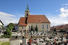
Nordansicht der röm.-kath. Pfarrkirche hl. Valentin in der oberösterreichischen Gemeinde Weyregg am Attersee.
Die spätgotische Kirche wurde in der zweiten Hälfte des 15. Jahrhunderts errichtet. 1931/1932 erfolgte eine Erweiterung Richtung Westen um rund acht Meter und im Anschluss erhielt die Kirche im südlichen Chorwinkel einen Kirchturm, nachdem sie bis dorthin nur einen Dachreiter hatte.
Autor: Rosso Robot, Licencja: CC BY-SA 3.0
Location map of Upper Austria
Equirectangular projection. Geographic limits of the map:
- N: 48.78063° N
- S: 47.44388° N
- W: 12.73041° E
- E: 15.00183° E


