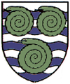
Whitby (North Yorkshire)
 | |||
| |||
| Państwo | |||
|---|---|---|---|
| Kraj | |||
| Region | |||
| Hrabstwo | |||
| Dystrykt | |||
| Populacja (2011) • liczba ludności |
| ||
| Nr kierunkowy | 01947 | ||
| Kod pocztowy | YO21, YO22 | ||
Położenie na mapie North Yorkshire Contains Ordnance Survey data © Crown copyright and database right, CC BY-SA 3.0 | |||
Położenie na mapie Wielkiej Brytanii (c) Karte: NordNordWest, Lizenz: Creative Commons by-sa-3.0 de | |||
| Strona internetowa | |||
| Portal | |||
Whitby – miasto i civil parish w północno-wschodniej Anglii, w hrabstwie North Yorkshire, w dystrykcie Scarborough[1]. Leży nad ujściem rzeki Esk do Morza Północnego, otoczone przez park narodowy North York Moors, w odległości 76,6 km od miasta York i 333 km od Londynu[2]. W 2011 roku civil parish liczyła 13 213 mieszkańców[3]. Whitby jest wspomniana w Domesday Book (1086) jako Witebi[4].
W Whitby znajdują się ruiny klasztoru, gdzie w 664 r. odbył się synod w Whitby.
Miasta partnerskie
 Anchorage, USA
 Porirua, Nowa Zelandia
 Whitby, Kanada
 Nukuʻalofa, Tonga
 Kauai County, USA
Przypisy
- ↑ Whitby. Ordnance Survey linked data. [dostęp 2016-04-09]. (ang.).
- ↑ Distance from WHITBY [NZ901113]. GENUKI. [dostęp 2016-04-09]. (ang.).
- ↑ Area: Whitby (Parish). Neighbourhood Statistics (ONS). [dostęp 2016-04-09]. [zarchiwizowane z tego adresu (2016-09-23)]. (ang.).
- ↑ Place name: Whitby, Yorkshire. The National Archives. [dostęp 2016-04-09]. (ang.).
Media użyte na tej stronie
Contains Ordnance Survey data © Crown copyright and database right, CC BY-SA 3.0
Map of North Yorkshire, UK with the following information shown:
- Administrative borders
- Coastline, lakes and rivers
- Roads and railways
- Urban areas
Equirectangular map projection on WGS 84 datum, with N/S stretched 170%
Geographic limits:
- West: 2.60W
- East: 0.10W
- North: 54.67N
- South: 53.60N
(c) Karte: NordNordWest, Lizenz: Creative Commons by-sa-3.0 de
Location map of the United Kingdom
Flag of England. Saint George's cross (a red cross on a white background), used as the Flag of England, the Italian city of Genoa and various other places.
The flag of Navassa Island is simply the United States flag. It does not have a "local" flag or "unofficial" flag; it is an uninhabited island. The version with a profile view was based on Flags of the World and as a fictional design has no status warranting a place on any Wiki. It was made up by a random person with no connection to the island, it has never flown on the island, and it has never received any sort of recognition or validation by any authority. The person quoted on that page has no authority to bestow a flag, "unofficial" or otherwise, on the island.
Flag of New Zealand. Specification: http://www.mch.govt.nz/nzflag/description.html , quoting New Zealand Gazette, 27 June 1902.
Flag of Canada introduced in 1965, using Pantone colors. This design replaced the Canadian Red Ensign design.
the coats of arms of Whitby Town Council, which features three green ammonites... Used this (archived here) and this (archived here) for reference.


