White (dopływ Wabash)
 Rzeka White w Indianapolis | |
| Kontynent | |
|---|---|
| Państwo | |
| Stan | |
| Długość | 384 km |
| Źródło | |
| Miejsce | hrabstwo Randolph |
| Wysokość | 350 m n.p.m. |
| Współrzędne | |
| Ujście | |
| Recypient | rzeka Wabash |
| Miejsce | koło Mount Carmel |
| Wysokość | 114 m n.p.m. |
| Współrzędne | |
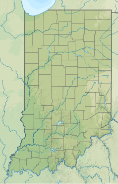
| Mapa | |
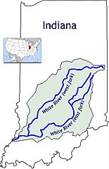
 Mapa dorzecza | |
White (ang. White River) – rzeka w Stanach Zjednoczonych, w stanie Indiana, przepływająca przez stolicę stanu – Indianapolis, dopływ rzeki Wabash. Długość rzeki wynosi 384 km[1][2].
Źródło rzeki znajduje się na terenie hrabstwa Randolph, na wysokości około 350 m n.p.m. W górnym biegu rzeka płynie w kierunku zachodnim, następnie zwraca się na południowy zachód. Około 80 km od ujścia, w pobliżu miasta Petersburg wpada do niej rzeka East Fork White (rzeka White od źródła do tego miejsca bywa nazywana West Fork White). Rzeka uchodzi do Wabash, u styku hrabstw Gibson, Knox (stan Indiana) i Wabash (stan Illinois), nieopodal miasta Mount Carmel, na wysokości 114 m n.p.m.[2][3]
Większe miasta położone nad rzeką to Winchester, Muncie, Anderson, Noblesville, Fishers, Carmel i Indianapolis[3].
Przypisy
- ↑ White River. Geographic Names Information System (GNIS). [dostęp 2019-01-11]. (ang.).
- ↑ a b White River, [w:] Encyclopædia Britannica [online] [dostęp 2019-01-11] (ang.).
- ↑ a b TopoView. U.S. Geological Survey. [dostęp 2019-01-11]. (ang.).
Media użyte na tej stronie
The flag of Navassa Island is simply the United States flag. It does not have a "local" flag or "unofficial" flag; it is an uninhabited island. The version with a profile view was based on Flags of the World and as a fictional design has no status warranting a place on any Wiki. It was made up by a random person with no connection to the island, it has never flown on the island, and it has never received any sort of recognition or validation by any authority. The person quoted on that page has no authority to bestow a flag, "unofficial" or otherwise, on the island.
Autor: Serge Melki from Indianapolis, USA, Licencja: CC BY 2.0
Janother hdr with CS5. i just combined the 5 shots. not too impressed with this picture. but if you ever take the walk on the river promenade... make sure the Dumbass security guy doesn't close the gate at the bridge side while you are still on the trail, because you will end up walking the 1.3miles on Washington St.to get back to your car. #$!#$@!$ ....
Autor: Oryginalnym przesyłającym był Davodd z angielskiej Wikipedii, Licencja: CC-BY-SA-3.0
Description: The two forks of the White River in en:Indiana. Source: Created by Davodd
Autor: SANtosito, Licencja: CC BY-SA 4.0
Relief location map of Indiana, USA
Geographic limits of the map:
- N: 42.0° N
- S: 37.6° N
- W: 88.3° W
- E: 84.6° W
Autor: Uwe Dedering, Licencja: CC BY-SA 3.0
Relief location map of the USA (without Hawaii and Alaska).
EquiDistantConicProjection : Central parallel :
* N: 37.0° N
Central meridian :
* E: 96.0° W
Standard parallels:
* 1: 32.0° N
* 2: 42.0° N
Made with Natural Earth. Free vector and raster map data @ naturalearthdata.com.
Formulas for x and y:
x = 50.0 + 124.03149777329222 * ((1.9694462586094064-({{{2}}}* pi / 180))
      * sin(0.6010514667026994 * ({{{3}}} + 96) * pi / 180))
y = 50.0 + 1.6155950752393982 * 124.03149777329222 * 0.02613325650382181
      - 1.6155950752393982  * 124.03149777329222 *
     (1.3236744353715044  - (1.9694462586094064-({{{2}}}* pi / 180))
      * cos(0.6010514667026994 * ({{{3}}} + 96) * pi / 180))


