Whitehaven
| ||
(c) Humphrey Bolton, CC BY-SA 2.0 Widok na Whitehaven | ||
| Państwo | ||
|---|---|---|
| Kraj | ||
| Region | North West | |
| Hrabstwo | Kumbria | |
| Dystrykt | Copeland | |
| Populacja (2001) • liczba ludności | 24 978 | |
| Nr kierunkowy | 01946 | |
| Kod pocztowy | CA28 | |
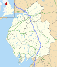
Położenie na mapie Kumbrii Contains Ordnance Survey data © Crown copyright and database right, CC BY-SA 3.0 | ||
Położenie na mapie Wielkiej Brytanii (c) Karte: NordNordWest, Lizenz: Creative Commons by-sa-3.0 de | ||
| Portal | ||
Whitehaven – miasto i civil parish w Wielkiej Brytanii, w Anglii, w regionie North West England, w hrabstwie Kumbria, w dystrykcie Copeland[1]. Leży 57,1 km od miasta Carlisle i 411,1 km od Londynu[2]. W 2001 roku miasto liczyło 24 978 mieszkańców[3].
W mieście odbywa się znany na całą Wielką Brytanię Whitehaven Festival.
W Whitehaven ma siedzibę klub rugby - Whitehaven RLFC.
Miasta partnerskie
Przypisy
- ↑ Whitehaven (ang.). Ordnance Survey linked data. [dostęp 2016-04-09].
- ↑ Distance from WHITEHAVEN [NX974181] (ang.). GENUKI. [dostęp 2016-04-09].
- ↑ KS01 Usual resident population: Census 2001, Key Statistics for urban areas (ang.). Office for National Statistics. [dostęp 2016-04-09]. [zarchiwizowane z tego adresu (2004-07-23)].
Media użyte na tej stronie
Contains Ordnance Survey data © Crown copyright and database right, CC BY-SA 3.0
Map of Cumbria, UK with the following information shown:
- Administrative borders
- Coastline, lakes and rivers
- Roads and railways
- Urban areas
Equirectangular map projection on WGS 84 datum, with N/S stretched 170%
Geographic limits:
- West: 3.80W
- East: 2.10W
- North: 55.20N
- South: 54.02N
(c) Karte: NordNordWest, Lizenz: Creative Commons by-sa-3.0 de
Location map of the United Kingdom
Flag of England. Saint George's cross (a red cross on a white background), used as the Flag of England, the Italian city of Genoa and various other places.
(c) Humphrey Bolton, CC BY-SA 2.0
Whitehaven Panorama. This is taken from the viewpoint above the Old Customs House, during the maritime Festival in June 2003. From here there are steep steps down to the quayside. The red sandstone tower of the old (ruined) church can be seen in the centre, and the present parish church has the grey tower to the left.


