Wielki Manchester
| Hrabstwo ceremonialne i metropolitalne | |||||
 Widok na miasta Stalybridge i Manchester (w tle) | |||||
| |||||
| Państwo | |||||
|---|---|---|---|---|---|
| Kraj | |||||
| Region | |||||
| Siedziba | |||||
| Powierzchnia | 1276 km² | ||||
| Populacja (2016) • liczba ludności |
| ||||
| • gęstość | 2180 os./km² | ||||
| Szczegółowy podział administracyjny | |||||
 | |||||
| Liczba dystryktów | 10 | ||||
Położenie na mapie | |||||
| Strona internetowa | |||||
| Portal | |||||
Wielki Manchester[1] (ang. Greater Manchester) – hrabstwo ceremonialne i metropolitalne w północno-zachodniej Anglii, w regionie North West England, obejmujące obszar aglomeracji miasta Manchester. Hrabstwo utworzone zostało w 1974 roku na pograniczu historycznych hrabstw Lancashire, Cheshire oraz Yorkshire[2].
Charakterystyka
Powierzchnia hrabstwa wynosi 1276 km², a liczba ludności – 2 782 141 (2016)[3], co czyni Wielki Manchester trzecim pod względem liczby mieszkańców hrabstwem ceremonialnym w Anglii (za Wielkim Londynem i West Midlands)[4]. Największym miastem hrabstwa jest Manchester, który do czasu likwidacji rady hrabstwa w 1986 roku był ośrodkiem administracyjnym hrabstwa. Innymi większymi miastami na terenie hrabstwa są Ashton-under-Lyne, Bolton, Stockport, Oldham, Rochdale, Wigan, Salford, Bury i Sale. Dwa miasta na terenie hrabstwa posiadają status city – Manchester oraz Salford[2].
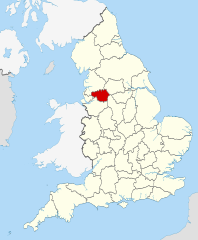
Na północy Wielki Manchester graniczy z hrabstwem Lancashire, na północnym wschodzie z West Yorkshire, na południowym wschodzie z Derbyshire, na południu z Cheshire a na zachodzie z Merseyside[2].
Podział administracyjny
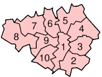
W skład hrabstwa wchodzi dziesięć dystryktów:
Mapa
Zobacz też
- Lista stacji i przystanków kolejowych w hrabstwie Wielki Manchester
Uwagi
- ↑ Do czasu likwidacji rady hrabstwa w 1986 roku.
Przypisy
- ↑ Urzędowy wykaz polskich nazw geograficznych świata. Główny Urząd Geodezji i Kartografii, 2019. s. 355. [dostęp 2022-07-29].
- ↑ a b c Greater Manchester, [w:] Encyclopædia Britannica [online] [dostęp 2012-07-08] (ang.).
- ↑ Population Estimates for UK, England and Wales, Scotland and Northern Ireland - Office for National Statistics, www.ons.gov.uk [dostęp 2017-10-21] (ang.).
- ↑ Table P04 2011 Census: Usual resident population by five-year age group, local authorities in England and Wales. Office for National Statistics. [dostęp 2012-07-18]. (ang.).
- ↑ Office for National Statistics: KS101EW - Usual resident population. [w:] 2011 Census [on-line]. Nomis – Official labour market statistics, 2013-02-12. [dostęp 2022-06-05]. (ang.).
- ↑ Office for National Statistics: Built-up Area to Local Authority District (December 2011) Lookup in England and Wales. [w:] Open Geography Portal [on-line]. [dostęp 2022-06-05]. (ang.).
- ↑ Office for National Statistics: Built-up Area Sub Divisions (December 2011) Boundaries. [w:] Open Geography Potal [on-line]. [dostęp 2022-06-05]. (ang.).
Media użyte na tej stronie
Flag of England. Saint George's cross (a red cross on a white background), used as the Flag of England, the Italian city of Genoa and various other places.
Autor: Ta PNG grafika rastrowa została stworzona za pomocą Inkscape., Licencja: CC BY-SA 3.0
The Coat of arms of Greater Manchester County Council.
Contains Ordnance Survey data © Crown copyright and database right, CC BY-SA 3.0
Map of Greater Manchester, UK with the following information shown:
- Administrative borders
- Coastline, lakes and rivers
- Roads and railways
- Urban areas
The data includes both primary routes and railway lines.
Equirectangular map projection on WGS 84 datum, with N/S stretched 165%
Geographic limits:
- West: 2.80W
- East: 1.90W
- North: 53.70N
- South: 53.32N
Autor: Nilfanion, Licencja: CC BY-SA 3.0
Location of the ceremonial county of Greater Manchester within England.
Autor: Ian Roberts, Licencja: CC BY-SA 2.0
Stalybridge in Greater Manchester, England, as viewed from Hollingworthhall Moor. The City of Manchester is seen beyond (westerly) in the background.
The County Flag of Greater Manchester is composed of ten golden castles (arranged in rows of 3-2-3-2) on a red background, fringed by a golden border in the style of a castle battlement.
NB: This is the official flag of Greater Manchester, adopted by Greater Manchester County Council in 1974. Despite the Council's abolition, the County (and Flag) remain.
The ten golden castles represent both the urban landscape of Greater Manchester, and its division in to its ten metropolitan districts: Bolton, Bury, Manchester, Oldham, Rochdale, Tameside, Trafford, Salford, Stockport, and Wigan. The red ground represents man-power and the county's red-brick architectural heritage, both legacies of Greater Manchester's industrial past. The embattled border represents the unity and shared future of the county, and its bold, vigilant and forward-looking character.
The blazon is: "Gules, ten Towers three two three two, all within a Bordure embattled Or".Autor: Morwen, Licencja: CC-BY-SA-3.0
A map of Greater Manchester, with each metropolitan borough numbered. Greater Manchester is a metropolitan county in North West England. The numbers correspond to the following boroughs:
- City of Manchester
- Stockport
- Tameside
- Oldham
- Rochdale
- Bury
- Bolton
- Wigan
- City of Salford
- Trafford


