Wilshire/Vermont
 Widok na peron stacji położony na górnym poziomie w kierunku Union Station | |
| Państwo | |
|---|---|
| Data otwarcia | 13 lipca 1996 |
| Poprzednia stacja | Westlake/MacArthur Park |
| Następna stacja | Vermont/Beverly (czerwona linia) Wilshire/Normandie (fioletowa linia) |
Położenie na mapie metropolii Los Angeles  | |
Położenie na mapie Stanów Zjednoczonych  | |
Położenie na mapie Kalifornii  | |
| Portal | |
Wilshire/Vermont – podziemna stacja dwóch linii metra w Los Angeles - czerwonej i fioletowej[1] znajdująca się na pograniczu dzielnic Mid-Wilshire i Koreatown przy skrzyżowaniu ulic Wilshire Boulevard i Vermont Avenue. Za stacją, w kierunku zachodnim, linie metra rozdzielają się na północ i zachód.
Na stacji znajduje się dwoje najdłuższych, ruchomych schodów w Kalifornii (w rzeczywistości na zachód od rzeki Missisipi)[2].
Połączenia autobusowe
- Metro Local: 18, 20, 51, 52, 201, 204, 352
- Metro Rapid: 720, 754
- Foothill Transit: 481
- LADOT DASH: Wilshire Center / Koreatown
Galeria zdjęć

Widok na peron stacji leżący na dolnym poziomie w kierunku stacji North Hollywood (linia czerwona) albo stacji Wilshire/Western (linia fioletowa)

Główne wejście na stację

Schody ruchome

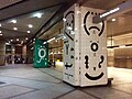
Artystyczne kolumny na górnym poziomie stacji
Artystyczne kolumny na dolnym poziomie stacji
Zobacz też
Linki zewnętrzne
Przypisy
- ↑ LA Metro Home | Go Metro, www.metro.net [dostęp 2017-11-27] (ang.).
- ↑ Transportation headlines, Monday, August 11 | The Source, thesource.metro.net [dostęp 2017-11-27] (ang.).

Media użyte na tej stronie
Autor: Alexrk2, Licencja: CC BY 3.0
Ta mapa została stworzona za pomocą GeoTools.
Autor: Uwe Dedering, Licencja: CC BY-SA 3.0
Location map of the USA (without Hawaii and Alaska).
EquiDistantConicProjection:
Central parallel:
* N: 37.0° N
Central meridian:
* E: 96.0° W
Standard parallels:
* 1: 32.0° N
* 2: 42.0° N
Made with Natural Earth. Free vector and raster map data @ naturalearthdata.com.
Formulas for x and y:
x = 50.0 + 124.03149777329222 * ((1.9694462586094064-({{{2}}}* pi / 180))
      * sin(0.6010514667026994 * ({{{3}}} + 96) * pi / 180))
y = 50.0 + 1.6155950752393982 * 124.03149777329222 * 0.02613325650382181
      - 1.6155950752393982  * 124.03149777329222 *
     (1.3236744353715044  - (1.9694462586094064-({{{2}}}* pi / 180))
      * cos(0.6010514667026994 * ({{{3}}} + 96) * pi / 180))
Autor: NordNordWest, Licencja: CC BY 3.0
Location map of California, USA

The flag of Navassa Island is simply the United States flag. It does not have a "local" flag or "unofficial" flag; it is an uninhabited island. The version with a profile view was based on Flags of the World and as a fictional design has no status warranting a place on any Wiki. It was made up by a random person with no connection to the island, it has never flown on the island, and it has never received any sort of recognition or validation by any authority. The person quoted on that page has no authority to bestow a flag, "unofficial" or otherwise, on the island.

Red Line circle.

Purple Line circle.

Silver Line square (for Los Angeles Metro).

Autor: Buchanan-Hermit, Licencja: Attribution
Wilshire/Vermont Station of the LA Metro Rail's Red Line. Los Angeles, CA, USA.

Autor: HanSangYoon, Licencja: CC BY-SA 4.0
The lower floor pillar of Wilshire/Vermont Station.

The icon for the Metro A line.
Autor: HanSangYoon, Licencja: CC BY-SA 4.0
The upper platform view of Wilshire/Vermont Station.

Autor: HanSangYoon, Licencja: CC BY-SA 4.0
The upper platform pillar of Wilshire/Vermont Station.

Gold Line circle.

Autor: HanSangYoon, Licencja: CC BY-SA 4.0
The main entrance of Wilshire/Vermont Station.

Orange Line square (for Los Angeles Metro).

Autor: HanSangYoon, Licencja: CC BY-SA 4.0
The escalator of Wilshire/Vermont Station.