Wilshire Boulevard
| ||
Wilshire Blvd w okolicach Westwood | ||
| Państwo | ||
| Miejscowość | Los Angeles | |
| Plan | ||
 | ||
Położenie na mapie metropolii Los Angeles  | ||
Położenie na mapie Stanów Zjednoczonych  | ||
Położenie na mapie Kalifornii  | ||
Wilshire Boulevard – ulica w hrabstwie Los Angeles biegnąca ze wschodu na zachód. Rozciąga się od Ocean Avenue przy Oceanie Spokojnym w Santa Monica do śródmieścia (downtown) Los Angeles; długość – ok. 25 km (16 mil). Wzdłuż bulwaru skoncentrowane jest życie biznesowe Santa Monica, Beverly Hills oraz Los Angeles. Przy Wilshire Blvd znajdują się przedstawicielstwa konsularne wielu państw, także Konsulat Generalny Rzeczypospolitej Polskiej.
Galeria zdjęć
Wilshire Boulevard na wysokości Los Angeles County Museum of Art w 1965 roku
 (c) DaveofCali, CC BY 2.0
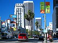
Miracle Mile
Wilshire Boulevard przebiegająca przez dzielnicę Brentwood
Wilshire Boulevard przechodząca przez rejon Koreatown

Autobus linii 720 należący do systemu Metro Rapid jadący w kierunku miasta Santa Monica

Pociąg fioletowej linii metra

Wilshire Regent

LACMA (dawniej May Company Department Store
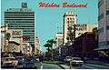
Wilshire Boulevard na wysokości Miracle Mile na pocztówce z lat sześćdziesiątych

Wilshire Boulevard przebiegająca przez wschodnią granicę miasta Beverly Hills
| ||||||||||||||||||
Media użyte na tej stronie
Autor: Uwe Dedering, Licencja: CC BY-SA 3.0
Location map of the USA (without Hawaii and Alaska).
EquiDistantConicProjection:
Central parallel:
* N: 37.0° N
Central meridian:
* E: 96.0° W
Standard parallels:
* 1: 32.0° N
* 2: 42.0° N
Made with Natural Earth. Free vector and raster map data @ naturalearthdata.com.
Formulas for x and y:
x = 50.0 + 124.03149777329222 * ((1.9694462586094064-({{{2}}}* pi / 180))
      * sin(0.6010514667026994 * ({{{3}}} + 96) * pi / 180))
y = 50.0 + 1.6155950752393982 * 124.03149777329222 * 0.02613325650382181
      - 1.6155950752393982  * 124.03149777329222 *
     (1.3236744353715044  - (1.9694462586094064-({{{2}}}* pi / 180))
      * cos(0.6010514667026994 * ({{{3}}} + 96) * pi / 180))
Autor: NordNordWest, Licencja: CC BY 3.0
Location map of California, USA

The flag of Navassa Island is simply the United States flag. It does not have a "local" flag or "unofficial" flag; it is an uninhabited island. The version with a profile view was based on Flags of the World and as a fictional design has no status warranting a place on any Wiki. It was made up by a random person with no connection to the island, it has never flown on the island, and it has never received any sort of recognition or validation by any authority. The person quoted on that page has no authority to bestow a flag, "unofficial" or otherwise, on the island.

Crossroads with a major road ahead.

Autor: Downtowngal, Licencja: CC BY-SA 3.0
Large office building on the eastern edge of Beverly Hills, California.
Autor: Alexrk2, Licencja: CC BY 3.0
Ta mapa została stworzona za pomocą GeoTools.

(c) DaveofCali z angielskojęzycznej Wikipedii, CC-BY-SA-3.0
Wilshire Blvd. in Wilshire Center (Koreatown), Los Angeles.

(c) DaveofCali z angielskojęzycznej Wikipedii, CC-BY-SA-3.0
Wilshire Boulevard in Brentwood

Color photocrome postcard of Wilshire Boulevard through the Miracle Mile district of Los Angeles, California during the early 1960s. The Lee Tower (built in 1958 by D. Everett Lee) is seen on the left-hand side background, the Mullen & Bluett building (built in 1949 by Stiles O. Clements) is seen on the right-hand side foreground and the Desmond's Hancock Park Store (built in 1928 by Gilbert S. Underwood) is seen on the right-hand side background. View looking east on Wilshire Boulevard between South Ridgeley Street and South Burnside Avenue. The back of the postcard reads:
ON THE MIRACLE MILE
WILSHIRE BOULEVARD
LOS ANGELES, CALIFORNIA
Extending from downtown Los Angeles to the ocean at Santa Monica, this famous boulevard is one of the most beautiful thoroughfares in the United States.
COLOR PHOTO BY ELLIS-SAWYER
L.169–WESTERN PUBL. & NOV. CO., 259 SO. LOS ANGELES ST., L.A., CALIF.
CURTEICHCOLOR ® 3-D NATURAL COLOR REPRODUCTION (REG. U. S. A. PAT OFF.)

Purple Line subway train of the Los Angeles County Metropolitan Transit Authority, at Union Station, Los Angeles, California.


Former 1930s May Company department store — Art Deco and Streamline Moderne architecture styles.
- Formerly part of the Los Angeles County Museum of Art campus.
- Future home of The Academy Museum of Motion Pictures, opening 2019.
- Located on Wilshire Boulevard, at the western end of the Miracle Mile, Los Angeles.

(c) GeorgeLouis z angielskiej Wikipedii, CC BY-SA 3.0
Automobile traffic and people waiting to cross Wilshire Boulevard in front of the Los Angeles County Museum of Art, 1965
- Other information

A en:NABI 60-BRT coach, owned and operated by the en:Los Angeles County Metropolitan Transportation Authority.

(c) DaveofCali, CC BY 2.0
Miracle Mile as seen from near Wilshire & La Brea in early 2004, looking westward. The tallest buildings are Desmond's (offices/condos; formerly a dep't store) and 5550 Wilshire (luxury apartments).
Autor: Arturoramos, Licencja: CC BY 3.0
Map of Wilshire Boulevard - in Los Angeles and other cities of Los Angeles County, Southern California.