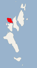
Wilson Island (Archipelag Ritchie)
| ||
 | ||
| Kontynent | Azja Południowa | |
| Państwo | ||
| Akwen | Ocean Indyjski | |
| Archipelag | Ritchie | |
| Powierzchnia | 14 km² | |
Wilson Island – jedna z mniejszych wysp środkowej części Archipelagu Ritchie w Andamanach, zajmuje obszar 14 km².
Media użyte na tej stronie
The Flag of India. The colours are saffron, white and green. The navy blue wheel in the center of the flag has a diameter approximately the width of the white band and is called Ashoka's Dharma Chakra, with 24 spokes (after Ashoka, the Great). Each spoke depicts one hour of the day, portraying the prevalence of righteousness all 24 hours of it.
Ritchie's Archipelago Wilson Island (Andaman Islands)
Autor: NordNordWest, Licencja: CC BY-SA 3.0 de
Location map of teh Andaman and Nicobar Islands, India
Autor: Uwe Dedering, Licencja: CC BY-SA 3.0
Location map of India.
Equirectangular projection. Stretched by 106.0%. Geographic limits of the map:
- N: 37.5° N
- S: 5.0° N
- W: 67.0° E
- E: 99.0° E


