Wiltshire
| Hrabstwo ceremonialne | |||||
 Stonehenge, położone w południowej części hrabstwa | |||||
| |||||
| Państwo | |||||
|---|---|---|---|---|---|
| Kraj | |||||
| Region | |||||
| Siedziba | |||||
| Powierzchnia | 3485 km² | ||||
| Populacja (2011) • liczba ludności |
| ||||
| • gęstość | 195,2 os./km² | ||||
| Szczegółowy podział administracyjny | |||||
 | |||||
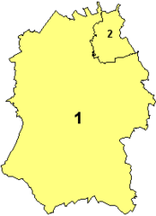
| Liczba unitary authorities | 2 | ||||
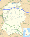
Położenie na mapie | |||||
| Strona internetowa | |||||
| Portal | |||||
Wiltshire – hrabstwo ceremonialne i historyczne w południowej Anglii, w regionie South West England, obejmujące dwie jednostki administracyjne typu unitary authority – Wiltshire oraz Swindon. Do 2009 roku Wiltshire pełniło funkcję hrabstwa administracyjnego (niemetropolitalnego). Historyczną stolicą hrabstwa było miasto Wilton, a od 1930 roku Trowbridge.
Powierzchnia hrabstwa wynosi 3485 km². Liczba ludności w 2011 roku wyniosła 680 200[1].
Geografia
Wiltshire jest hrabstwem nizinnym, charakteryzującym się równinnym krajobrazem z łagodnymi kredowymi pagórkami. Znaczną część hrabstwa zajmuje równina Salisbury Plain, na której znajduje się m.in. megalityczna budowla Stonehenge.
Hrabstwo ma w przeważającej części charakter wiejski. Największym miastem jest Swindon, położone na północno-wschodnim krańcu hrabstwa. Drugim pod względem wielkości miastem, a zarazem jednym o statusie city, jest Salisbury, w południowo-wschodniej części hrabstwa. Inne większe miasta to Chippenham oraz Trowbridge.
Na zachodzie Wiltshire graniczy z hrabstwem Somerset, na północy z Gloucestershire, na północnym wschodzie z Oxfordshire, na wschodzie z Berkshire, na południowym wschodzie z Hampshire, a na południowym zachodzie z hrabstwem Dorset.
Głównymi zabytkami na terenie hrabstwa, obok Stonehenge, są kamienny krąg w Avebury, katedra w Salisbury oraz rezydencje Longleat House i Stourhead.
Podział administracyjny
Obecny
- Wiltshire (unitary authority)
- Swindon (unitary authority)
Do 2009 roku
- Salisbury
- West Wiltshire
- Kennet
- North Wiltshire
- Swindon (unitary authority)
Mapa
Przypisy
- ↑ Table P04 2011 Census: Usual resident population by five-year age group, local authorities in England and Wales. Office for National Statistics. [dostęp 2012-07-18]. (ang.).
- ↑ Office for National Statistics: KS101EW - Usual resident population. [w:] 2011 Census [on-line]. Nomis – Official labour market statistics, 2013-02-12. [dostęp 2022-06-05]. (ang.).
- ↑ Office for National Statistics: Built-up Area to Local Authority District (December 2011) Lookup in England and Wales. [w:] Open Geography Portal [on-line]. [dostęp 2022-06-05]. (ang.).
- ↑ Office for National Statistics: Built-up Area Sub Divisions (December 2011) Boundaries. [w:] Open Geography Potal [on-line]. [dostęp 2022-06-05]. (ang.).
Bibliografia
- Wiltshire, [w:] Encyclopædia Britannica [online] [dostęp 2011-09-02] (ang.).
Media użyte na tej stronie
Contains Ordnance Survey data © Crown copyright and database right, CC BY-SA 3.0
Map of Wiltshire, UK with the following information shown:
- Administrative borders
- Coastline, lakes and rivers
- Roads and railways
- Urban areas
Equirectangular map projection on WGS 84 datum, with N/S stretched 160%
Geographic limits:
- West: 2.40W
- East: 1.35W
- North: 51.72N
- South: 50.92N
Flag of England. Saint George's cross (a red cross on a white background), used as the Flag of England, the Italian city of Genoa and various other places.
County Flag of Wiltshire
Autor: Keith Edkins, Licencja: CC-BY-SA-3.0
Unitary Authorities in the Ceremonial County of Wiltshire, effective 1st April 2009.
- 1. Wiltshire Council
- 2. Swindon
Autor: Nilfanion, Licencja: CC BY-SA 3.0
Location of the ceremonial county of Wiltshire within England.
Autor: Simon Wakefield, Licencja: CC BY-SA 2.0
3 RAW files used for this HDR, put together using Photomatix.


