Windle
(c) David Long, CC BY-SA 2.0 | |
| Państwo | |
|---|---|
| Kraj | |
| Hrabstwo | Merseyside |
| Dystrykt | St. Helens |
| Populacja (2011) • liczba ludności | 2546 |
| Nr kierunkowy | 01744 |
Położenie na mapie Merseyside Contains Ordnance Survey data © Crown copyright and database right, CC BY-SA 3.0 | |
Położenie na mapie Wielkiej Brytanii (c) Karte: NordNordWest, Lizenz: Creative Commons by-sa-3.0 de | |
| 53,4689°N 2,7673°W/53,468900 -2,767300 | |
| Portal | |
Windle – osada i civil parish w Anglii, w Merseyside, w dystrykcie St. Helens[1]. W 2011 civil parish liczyła 2546 mieszkańców[2].
Przypisy
Linki zewnętrzne
Media użyte na tej stronie
(c) Karte: NordNordWest, Lizenz: Creative Commons by-sa-3.0 de
Location map of the United Kingdom
Flag of England. Saint George's cross (a red cross on a white background), used as the Flag of England, the Italian city of Genoa and various other places.
Contains Ordnance Survey data © Crown copyright and database right, CC BY-SA 3.0
Map of Merseyside, UK with the following information shown:
- Administrative borders
- Coastline, lakes and rivers
- Roads and railways
- Urban areas
Equirectangular map projection on WGS 84 datum, with N/S stretched 165%
Geographic limits:
- West: 3.24W
- East: 2.54W
- North: 53.72N
- South: 53.27N
(c) David Long, CC BY-SA 2.0
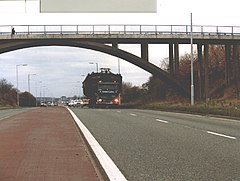
Bridge over the A580 East Lancs Road at Windle. The lorry is carrying the barge BARMERE from Liverpool Docks for restoration in St. Helens. Pictures of her next journey, to Widnes in October 2005, are elsewhere. See:http://www.scars.org.uk/cuttings/volume6/issue6-1/move.html


