Windsor and Maidenhead
| ||||
| ||||
 Maidenhead | ||||
| Państwo | ||||
| Kraj | ||||
| Region | South East England | |||
| Hrabstwo | Berkshire | |||
| Siedziba | Maidenhead | |||
| Powierzchnia | 198,43 km² | |||
| Populacja (2011) • liczba ludności | 145 100 | |||
| • gęstość | 730 os./km² | |||
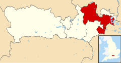
| Położenie na mapie Berkshire Contains Ordnance Survey data © Crown copyright and database right, CC BY-SA 3.0 | ||||
| Strona internetowa | ||||
| Portal | ||||
Windsor and Maidenhead – okręg miejski hrabstwa Berkshire, South East England. Od 1 kwietnia 1998 r. unitary authority.
Okręg został utworzony 1 kwietnia 1974 r. jako jednostka składowa hrabstwa Berkshire na mocy Local Government Act 1972 (ustawy Parlamentu angielskiego reformującej podział administracyjny Anglii i Walii. W 2011 roku dystrykt liczył 144 560 mieszkańców[1].
Na terenie okręgu znajduje się Zamek Windsor.
Miasta
Inne miejscowości
Bisham, Burchetts Green, Clewer, Cookham, Datchet, Dedworth, Eton Wick, Fifield, Hawthorn Hill, Holyport, Hurley, Littlewick Green, Old Windsor, Paley Street, Shurlock Row, Sunningdale, Sunninghill, Touchen-end, Warren Row, White Waltham, Wraysbury.
Miasta partnerskie
 Francja, Neuilly-sur-Seine - od 1955 r. z okręgiem New Windsor.
 Francja, Saint-Cloud - od 1957 r. z Maidenhead.
 Niemcy, Bad Godesberg - od 1960 r. z Maidenhead.
 Niemcy, Goslar - od 1969 r. z okręgiem New Windsor.
 Włochy, Frascati - od 1972 r. z Maidenhead.
 Belgia. Kortrijk - od 1981 r. z okręgiem Windsor and Maidenhead.
Przypisy
- ↑ Area: Windsor and Maidenhead (Local Authority) (ang.). Neighbourhood Statistics (ONS). [dostęp 2016-05-06].
Media użyte na tej stronie
Flag of England. Saint George's cross (a red cross on a white background), used as the Flag of England, the Italian city of Genoa and various other places.
Autor: Tom Bastin from Reading, UK, Licencja: CC BY 2.0
The Rose, King Street, Maidenhead. Built 1881
Contains Ordnance Survey data © Crown copyright and database right, CC BY-SA 3.0
Map of Berkshire, UK with Windsor and Maidenhead highlighted.
Equirectangular map projection on WGS 84 datum, with N/S stretched 160%


