Woking
(c) Ron Strutt, CC BY-SA 2.0 | |
| Państwo | |
|---|---|
| Kraj | |
| Hrabstwo | |
| Dystrykt | |
| Populacja • liczba ludności |
|
| Nr kierunkowy | 01483 |
| Kod pocztowy | GU21, GU22 |
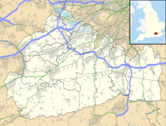
Położenie na mapie Surrey Contains Ordnance Survey data © Crown copyright and database right, CC BY-SA 3.0 | |
Położenie na mapie Wielkiej Brytanii (c) Karte: NordNordWest, Lizenz: Creative Commons by-sa-3.0 de | |
| Strona internetowa | |
| Portal | |
Woking – miasto w Wielkiej Brytanii położone w zachodniej części Surrey, w dystrykcie Woking, w pobliżu Londynu (37 km na południowy zachód od Charing Cross), należące do Greater London Urban Area (inaczej Greater London Built-up Area).
W mieście znajduje się siedziba McLaren Technology Centre zespołu Formuły 1 McLaren.
Odniesienia w kulturze
- Woking jest wspomniane w Domesday Book (1086) jako Wochinges[1].
- Woking jest miejscem rozpoczęcia fabuły książki Wojna światów autorstwa Herberta George'a Wellsa. To właśnie w tym miasteczku wylądował pierwszy pojazd Marsjan, którzy rozpoczynają inwazję na Ziemię.
- Akcja kryminalnej serii z Davidem Redfernem autorstwa Anny Rozenberg rozgrywa się na terenie Woking. Woking pojawia się we wszystkich trzech książkach serii: Maski pośmiertne[2], Punkty zapalne[3] i Wszyscy umarli[4].
Miasta partnerskie
Przypisy
- ↑ Surrey. The Domesday Book online. [dostęp 2016-05-13]. (ang.).
- ↑ Maski pośmiertne, Czwarta Strona [dostęp 2022-03-30] (pol.).
- ↑ Punkty zapalne, Czwarta Strona [dostęp 2022-03-30] (pol.).
- ↑ Wszyscy umarli, Czwarta Strona [dostęp 2022-03-30] (pol.).
Linki zewnętrzne
- Serwis internetowy Woking Borough Council. woking.gov.uk. [zarchiwizowane z tego adresu (2011-07-16)].
Media użyte na tej stronie
(c) Karte: NordNordWest, Lizenz: Creative Commons by-sa-3.0 de
Location map of the United Kingdom
Flag of England. Saint George's cross (a red cross on a white background), used as the Flag of England, the Italian city of Genoa and various other places.
(c) Ron Strutt, CC BY-SA 2.0
Woking Town Square. In 1838 when the railway arrived, Woking town centre was open heathland. The town developed in a fairly piecemeal fashion and had reached a form of completion by the mid-1980s, when redevelopment began again. A short-lived town centre swimming pool disappeared as part of those changes, to be replaced by the Pool in the Park. The present form of the town centre, including the modern library, the Peacocks shopping centre, and the refashioned Wolsey Way centre date from that time.
Contains Ordnance Survey data © Crown copyright and database right, CC BY-SA 3.0
Map of Surrey, UK with the following information shown:
- Administrative borders
- Coastline, lakes and rivers
- Roads and railways
- Urban areas
Equirectangular map projection on WGS 84 datum, with N/S stretched 160%
Geographic limits:
- West: 0.87W
- East: 0.08E
- North: 51.50N
- South: 51.05N


