Woluwe-Saint-Lambert
 | |||||
| Państwo | |||||
|---|---|---|---|---|---|
| Prowincja | Bruksela | ||||
| Burmistrz | Olivier Maingain (od 2006) | ||||
| Powierzchnia | 7,22 km² | ||||
| Populacja (2008) • liczba ludności • gęstość | 49 261 6823 os./km² | ||||
| Nr kierunkowy | 02 | ||||
| Kod pocztowy | 1200 | ||||
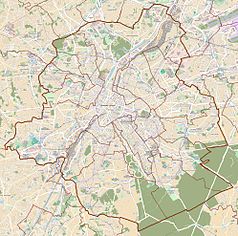
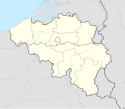
Położenie na mapie Belgii (c) Karte: NordNordWest, Lizenz: Creative Commons by-sa-3.0 de | |||||
| Strona internetowa | |||||
Woluwe-Saint-Lambert (nid. Sint-Lambrechts-Woluwe) – gmina miejska w Belgii, jedna z 19 gmin Regionu Stołecznego Brukseli, licząca około 58 tys. mieszkańców, w tym niemal 38% obcokrajowców (2021[1]). Oficjalnie dwujęzyczna ((fr./nider.) Dzielnica rezydencyjno-parkowa.
Miasta partnerskie
Przypisy
- ↑ Woluwe-Saint-Lambert | IBSA, ibsa.brussels [dostęp 2022-01-13].
Media użyte na tej stronie
(c) Karte: NordNordWest, Lizenz: Creative Commons by-sa-3.0 de
Location map of Belgium
Flag of Rwanda. The flag ratio is 2:3 with the stripes being 2:1:1. Colors are the following officially: Pantone 299 C 2X (blue), RAL 6029 (green), RAL 1023 (yellow) and RAL 1003 (golden yellow). (As of 03/08/2010, the only color used is the Pantone 299 C, which is from here. The rest of the colors are RAL shades from here.)
Autor: Matthew Ross (Matthewross), Licencja: CC-BY-SA-3.0
Avenue de Broqueville, Woluwe-Saint-Lambert, Brussels, Belgium
Wapen van de gemeente Sint-Lambrechts-Woluwe
Autor: , Licencja: CC BY-SA 3.0


