Worcester
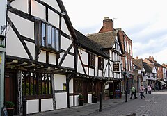
 Budynki z okresu Tudorów przy Friar Street w Worcester | |||
| |||
| Państwo | |||
|---|---|---|---|
| Kraj | |||
| Region | |||
| Hrabstwo | |||
| Dystrykt | Worcester | ||
| Powierzchnia | 33,28 (dystrykt) km² | ||
| Populacja (2001) • liczba ludności • gęstość |
| ||
| Nr kierunkowy | 01905 | ||
| Kod pocztowy | WR1 - WR5 | ||
Położenie na mapie Worcestershire Contains Ordnance Survey data © Crown copyright and database right, CC BY-SA 3.0 | |||
Położenie na mapie Wielkiej Brytanii (c) Karte: NordNordWest, Lizenz: Creative Commons by-sa-3.0 de | |||
| Strona internetowa | |||
| Portal | |||
Worcester (wym. /ˈwʊstə/) – miasto i dystrykt w Wielkiej Brytanii (Anglia), o statusie city, ośrodek administracyjny hrabstwa Worcestershire. Liczy około 93,6 tysięcy mieszkańców i położone jest 48 km od Birmingham. W 2001 roku miasto liczyło 94 029 mieszkańców[2]. W 2011 roku dystrykt liczył 98 768 mieszkańców[3]. W mieście wynaleziono oraz długi czas produkowano sos Worcestershire[4].
W mieście rozwinął się przemysł maszynowy, metalowy, porcelanowy, skórzany oraz spożywczy[5].
Położenie
Worcester znajduje się w regionie West Midlands w Anglii. Miasto jest położone 48 km na południowy wschód od Birmingham i 47 km na północ od Gloucester. Przez miasto przepływa Rzeka Severn.
Civil parishes
- St. Peter the Great County i Warndon[6].
Inne miejscowości
- Arboretum, Battenhall, Bedwardine, Cathedral, Claines, Gorse Hill, Nunnery, Rainbow Hill, St. Clement, St. John, St. Peter’s Parish, St. Stephen, Warndon, Warndon Parish North i Warndon Parish South[6].
Historia
Osadnictwo na terenach dzisiejszego Worcester jest datowane do czasów neolitycznych; na wschodnim brzegu Rzeki Severn zostały odnalezione wały obronne otaczające osadę, datowane na 400 rok p.n.e. Miejsce to było wykorzystane do kontroli grodu przez Rzymian w I w n.e. Miało ono na celu pomoc w prawdopodobnie w budowie fortu na szlaku militarnym z Glevum (Gloucester) do Viroconium (Wroxeter). W 1041 roku miasto zostało spalone przez drużynę Hardekanuta w zemście za zabicie królewskich poborców podatkowych[7]. Worcester jest wspomniane w Domesday Book (1086) jako Wirecestre[8].
Worcester jest znane przede wszystkim ze względu na katedrę oraz jako miejsce urodzenia Edwarda Elgara.
Wizerunek Worcester Katedry znajdował się przez długie lata na banknotach £20.
Polonia
- Oddział Polski Niepodległej
- Polska Szkoła Sobotnia im. Jana Pawła II[9].
Współpraca
Przypisy
- ↑ The Guardian
- ↑ KS01 Usual resident population: Census 2001, Key Statistics for urban areas (ang.). Office for National Statistics. [dostęp 2016-01-20]. [zarchiwizowane z tego adresu (2004-07-23)].
- ↑ Neighbourhood Statistics. [dostęp 2017-02-21]. [zarchiwizowane z tego adresu (2017-02-22)].
- ↑ It's out after 170 years, the secret of Worcestershire Sauce... found in a skip (ang.). [dostęp 2009-11-15].
- ↑ Worcester, [w:] Encyklopedia PWN [online] [dostęp 2021-08-29].
- ↑ a b Ordnance Survey linked data
- ↑ Aron J. Guriewicz: Wyprawy wikingów. Warszawa: Wiedza Powszechna, 1969, s. 138.
- ↑ The Domesday Book online
- ↑ Baza organizacji i instytucji polskich i polonijnych za granicą. Główny Urząd Statystyczny. [dostęp 2018-08-12].
Media użyte na tej stronie
(c) Karte: NordNordWest, Lizenz: Creative Commons by-sa-3.0 de
Location map of the United Kingdom
Flag of England. Saint George's cross (a red cross on a white background), used as the Flag of England, the Italian city of Genoa and various other places.
The flag of Navassa Island is simply the United States flag. It does not have a "local" flag or "unofficial" flag; it is an uninhabited island. The version with a profile view was based on Flags of the World and as a fictional design has no status warranting a place on any Wiki. It was made up by a random person with no connection to the island, it has never flown on the island, and it has never received any sort of recognition or validation by any authority. The person quoted on that page has no authority to bestow a flag, "unofficial" or otherwise, on the island.
Autor:
- Worcestershire UK district map (blank).svg: Nilfanion, created using Ordnance Survey data
- derivative work: Renly (talk)
Map of Worcestershire, with Worcester highlighted.
Contains Ordnance Survey data © Crown copyright and database right, CC BY-SA 3.0
Map of Worcestershire, UK with the following information shown:
- Administrative borders
- Coastline, lakes and rivers
- Roads and railways
- Urban areas
Equirectangular map projection on WGS 84 datum, with N/S stretched 160%
Geographic limits:
- West: 2.68W
- East: 1.74W
- North: 52.47N
- South: 51.95N
Autor: Russ Hamer, Licencja: CC BY-SA 3.0
Some of several Tudor period buildings in Worcester
Ołtarz w katedrze w Worcester, Anglia


