Wyspa Henrietty
| ||
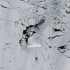
 Zdjęcie satelitarne wyspy, otoczonej lodem morskim | ||
| Kontynent | Azja | |
|---|---|---|
| Państwo | ||
| Republika | ||
| Akwen | Morze Wschodniosyberyjskie | |
| Archipelag | Wyspy Nowosyberyjskie | |
| Powierzchnia | 12 km² | |
Wyspa Henrietty (ros. Oстров Генриетты) – rosyjska wyspa na Morzu Wschodniosyberyjskim, w archipelagu Nowosyberyjskim, zaliczana do Wysp De Longa, położona najdalej na północ w tej grupie.
Wyspa ma powierzchnię 12 km², z tego 40% pokryte jest lodem. Została odkryta przez ekspedycję George'a De Longa na statku Jeannette.
Bibliografia
- Anisimov, M.A., and V.E. Tumskoy, 2002, Environmental History of the Novosibirskie Islands for the last 12 ka. 32nd International Arctic Workshop, Program and Abstracts 2002. Institute of Arctic and Alpine Research, University of Colorado at Boulder, pp 23–25.
- Anonymous, 1923, Wrangel Island. The Geographical Journal, Vol. 62, No. 6. pp. 440–444 (Dec., 1923). (requires JSTOR access).
- Headland, R.K., 1994, OSTROVA DE-LONGA ('De Long Islands'). Scott Polar Research Institute, Cambridge University. Lasted visited May 26, 2008.
- Schirrmeister, L., H.-W. Hubberten, V. Rachold, and V.G. Grosse, 2005, Lost world - Late Quaternary environment of periglacial Arctic shelves and coastal lowlands in NE-Siberia. 2nd International Alfred Wegener Symposium Bremerhaven, October, 30 - November 2, 2005.
Media użyte na tej stronie
Photo #: NH 92128
Jeannette Arctic exploring expedition, 1879-1881
Facsimile of a sketch made by Lieutenant Commander George DeLong on 25 May 1881, depicting "Henrietta Island", discovered by USS Jeannette as she drifted icebound north of Siberia. Position was about 157E, 77N. Copied from "The Voyage of the Jeannette ...", Volume II, page 551, edited by Emma DeLong, published in 1884.
U.S. Naval Historical Center Photograph.
Online Image: 39KB; 740 x 265 pixelsFlag of Sakha
Autor: Uwe Dedering, Licencja: CC BY-SA 3.0
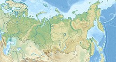
Location map of Russia.
EquiDistantConicProjection : Central parallel :
* N: 54.0° N
Central meridian :
* E: 100.0° E
Standard parallels:
* 1: 49.0° N
* 2: 59.0° N
Made with Natural Earth. Free vector and raster map data @ naturalearthdata.com.
The Advanced Land Imager (ALI) on NASA’s Earth Observing-1 satellite captured this image of Henrietta Island. In this natural-color image, the island casts shadows to the north, thanks to the Sun’s low angle and the island’s own steep, rugged coastline. Inland, an icy dome covers most of the island, its southern surface slightly illuminated.


