Wyspa Salisbury’ego
| ||
 Zdjęcie satelitarne: Wyspa Salisbury’ego znajduje się na lewo od centrum zdjęcia | ||
| Państwo | ||
| Obwód | ||
| Archipelag | Ziemia Franciszka Józefa | |
| Powierzchnia | 956,6 km² | |
 | ||
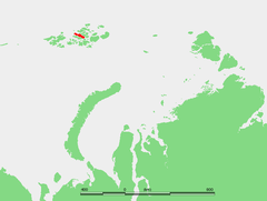
Wyspa Salisbury’ego[1] (ros. остров Солсбери) – wyspa położona w centralnej części rosyjskiego archipelagu Ziemia Franciszka Józefa. Wchodzi w skład grupy wysp, zwanej Wyspami Zichy lub Ziemią Zichy.
Ma kształt podłużny, wyciągnięty w kierunku z północnego zachodu na południowy wschód. Jest stosunkowo dużą wyspą: jej długość wynosi 64 km, maksymalna szerokość – 18 km, a powierzchnia – 960 km². Ma charakter wyżynny, najwyższy punkt wznosi się na 482 m n.p.m.[2] Większą jej część pokrywają czapy lodowe. Panuje tu klimat polarny. Ze względu na surowe warunki nie jest zamieszkana przez człowieka.
Wokół Wyspy Salisbury’ego jest niewiele otwartego morza, bowiem otaczają ją inne wyspy: wyspa Zieglera od strony północno-wschodniej, wyspa Wiener Neustadt od strony wschodniej oraz wyspy Luigiego i Champa od strony południowo-zachodniej. Od tej ostatniej wyspę Salisbury oddziela jedynie wąska, niespełna kilometrowej szerokości cieśnina.
Wyspę nazwano na cześć amerykańskiego geologa Rollina Salisbury’ego z Uniwersytetu w Chicago, uczestnika grenlandzkiej wyprawy Roberta Peary’ego w 1892 r.[3]
Od 1 stycznia 2006 r. administracyjnie należy (jak i cała Ziemia Franciszka Józefa) do rejonu primorskiego w obwodzie archangielskim.
Przypisy
- ↑ Zmiany wprowadzone na 80. posiedzeniu Komisji (26 czerwca 2013 roku), KSNG [dostęp 2013-08-08] (pol.).
- ↑ Islands of Russian Federation (ang.). Program Środowiskowy Organizacji Narodów Zjednoczonych, 1998-02-03. [dostęp 2013-01-15].
- ↑ Rollin D. Salisbury (ang.). Department of Geoscience, The University of Iowa. [dostęp 2013-01-15]. [zarchiwizowane z tego adresu (2013-01-26)].
Bibliografia
- Przeglądowy Atlas Świata, Popularna Encyklopedia Powszechna. Wyd. Fogra Oficyna Wydawnicza pod red. Rajmunda Mydela i Jerzego Grocha, Kraków 1999. ISBN 83-85719-31-8
Media użyte na tej stronie
Autor: Uwe Dedering, Licencja: CC BY-SA 3.0
Location map of Russia.
EquiDistantConicProjection : Central parallel :
* N: 54.0° N
Central meridian :
* E: 100.0° E
Standard parallels:
* 1: 49.0° N
* 2: 59.0° N
Made with Natural Earth. Free vector and raster map data @ naturalearthdata.com.
Salisbury Island
Autor: Nzeemin, Licencja: CC BY-SA 3.0
Физическая карта -- Земля Франца-Иосифа, Россия.
- Проекция: Lambert Azimuthal Equal-Area
- Longitude and latitude of the projection center: 55 / 80.8
- Инструменты: GMT
Флаг Архангельской области
Autor: NASA's Earth Observatory, Licencja: CC BY 2.0
To download the full resolution and other files go to: earthobservatory.nasa.gov/IOTD/view.php?id=76883&src=...
Located just 600 miles (970 kilometers) from the North Pole, Franz Josef Land is perpetually coated with ice. Glaciers cover roughly 85 percent of the archipelago’s land masses, and sea ice floats in the channels between islands even in the summertime.
The Advanced Spaceborne Thermal Emission and Reflection Radiometer (ASTER) on NASA’s Terra satellite observed the islands of central Franz Josef Land on August 16 and 19, 2011. (Another sensor on Terra captured a wider view on August 17, 2011.)
The image above was made from a combination of visible and near-infrared wavelengths, and ice appears in shades of white and pale blue. The amount of sea ice filling the channels between the islands of Franz Josef Land varies from summer to summer. Captured toward the end of the Northern Hemisphere melt season, this shot shows a modest amount of sea ice on the ocean surface. Some of the ice has accumulated in bays like the one near northeastern Zieger Island.
Most of the ice in this scene is anchored to land, as large glaciers blanket the islands. Yet today’s glaciers are tiny compared to the ice sheet that dominated the region about 20,000 years ago. Studies of Franz Josef Land have actually contributed to a larger understanding of when that massive ice sheet began its slow retreat. Raised beaches, which preserve evidence of land rising as the crushing weight of overlying glaciers eases (known as isostatic rebound), were first recognized on the islands in the late nineteenth century. Researchers estimate that the giant ice sheet had retreated by about 10,000 years ago.
NASA image created by Jesse Allen, using data provided courtesy of NASA/GSFC/METI/ERSDAC/JAROS, and U.S./Japan ASTER Science Team. Caption by Michon Scott with information from Walt Meier and Ted Scambos, National Snow and Ice Data Center.
The Earth Observatory's mission is to share with the public the images, stories, and discoveries about climate and the environment that emerge from NASA research, including its satellite missions, in-the-field research, and climate models.
Like us on Facebook
Follow us on Twitter
Add us to your circles on Google+


