Wyspa Victorii
| ||
 | ||
| Kontynent | Europa | |
| Państwo | ||
| Obwód | ||
| Akwen | Ocean Arktyczny | |
| Powierzchnia | ~40 km² | |
| Populacja • liczba ludności | 0 | |
 | ||
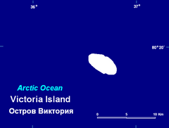
Wyspa Victorii[1] (ros. Остров Виктория, trl. Ostrow Wiktorija) – samotna wyspa położona na Oceanie Arktycznym na północy Morza Barentsa, pomiędzy dużymi archipelagami Ziemi Franciszka Józefa i Svalbardu; jest to najdalej na zachód położona wyspa rosyjskiej Arktyki.
Wyspa jest owalna, prawie w całości pokryta lodem. Została odkryta 20 lipca 1898 roku przez Norwegów, a następnego dnia dostrzeżona przez kapitana jachtu Victoria, od którego to statku pochodzi nazwa wyspy (w Polsce spotykana jest również niepoprawna polskojęzyczna wersja „Wyspa Wiktorii”, sugerująca pochodzenie nazwy od osoby[1]). W 1926 roku została uznana przez Związek Socjalistycznych Republik Radzieckich za część jego terytorium. W latach 1929-30 Norwegia podjęła tajne działania w celu przyłączenia jej do swojego terytorium; w 1932 roku wyspa ostatecznie stała się własnością radziecką[2].
Przypisy
- ↑ a b Protokół 80. posiedzenia Komisji Standaryzacji Nazw Geograficznych poza Granicami Rzeczypospolitej Polskiej (pol.). ksng.gugik.gov.pl, 2013-06-26. [dostęp 2020-02-25].
- ↑ I. Gjertz, B. Mørkved. Norwegian Arctic Expansionism, Victoria Island (Russia) and the Bratvaag Expedition. „Arctic”. 51 (4), s. 330-335, grudzień 1998. [dostęp 2014-01-28].
Media użyte na tej stronie
Autor: Uwe Dedering, Licencja: CC BY-SA 3.0
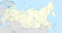
Location map of Russia.
EquiDistantConicProjection : Central parallel :
* N: 54.0° N
Central meridian :
* E: 100.0° E
Standard parallels:
* 1: 49.0° N
* 2: 59.0° N
Made with Natural Earth. Free vector and raster map data @ naturalearthdata.com.
Because the southern Kuril islands are claimed by Russia and Japan, they are shown as disputed. For more information about this see: en:Kuril Islands dispute. These islands are since 1945 under the jurisdiction of the Russian Federation.
Map of Victoria Island, Russia
5 crewmembers of the Norwegian ship Bratvaag posing next to the symbol which contains a text that Victoria Island is claimed for shipowner Harald M. Leite (and thereby de facto for the Norwegian crown). In the back building material for a hut, which was not constructed due to the impossibility to guard it against storms. The claim, which was put up in secrecy, was never made official by the Norwegian authorities, which secretly supported the claim but perhaps feared a conflict with the Soviet Union.
Two years later on the island was erected a Soviet flag to effectuate a Soviet claim from 1926 (disputed by Norway), annexing the island and Franz Jozefland to the Soviet Union.Флаг Архангельской области
Autor: Nzeemin, Licencja: CC BY-SA 2.0
Физическая карта Архангельской области, включая Ненецкий автономный округ, Новая Земля, Земля Франца-Иосифа.
- Проекция: Equidistant conic projection
- Проекция и координаты для GMT: -JD50/65/60/75/8 -R37/60/85.8/80.4r
- Инструменты: GMT, Inkscape
Victoria island, Russia


