Wyspy Włoch
Na Morzu Tyrreńskim
Sardynia
Sycylia
Prowincja Mesyna
Prowincja Agrigento
Prowincja Trapani
Prowincja Caltanissetta
Toskania
Prowincja Livorno
Lacjum
Prowincja Latina
Na rzekach
Lacjum
Prowincja Rzym
Media użyte na tej stronie
Autor: Autor nie został podany w rozpoznawalny automatycznie sposób. Założono, że to NormanEinstein (w oparciu o szablon praw autorskich)., Licencja: CC-BY-SA-3.0
A map of the Pontine Islands off the west coast of Italy, in the Tyrrhenian Sea. This maps shows the islands of Ponza, Ventotene, Zannone, Palmarola, Gavi, and Santo Stefano.
Created by NormanEinstein, May 16, 2005.Autor: Created by NormanEinstein, Licencja: CC-BY-SA-3.0
A map of the Tuscan archipelago, including the islands Elba, Capraia, Giglio, Montecristo, Pianosa, Gorgona, and Giannutri. Tyrrhenian Sea.
Autor: Autor nie został podany w rozpoznawalny automatycznie sposób. Założono, że to NormanEinstein (w oparciu o szablon praw autorskich)., Licencja: CC-BY-SA-3.0
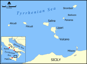
This is a map of the Aeolian Islands off the coast of Sicily, Italy in the Tyrrhenian Sea. The map shows the location of the islands of Salina, Lipari, Vulcano, Alicudi, Filicudi, Panarea, Basiluzzo, and Stromboli. Blank version available at Image:Aeolian Islands blank map.png.
Created by NormanEinstein.


