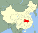
Xiaogan
| ||
 | ||
| Państwo | ||
|---|---|---|
| Prowincja | Hubei | |
| Powierzchnia | prefektura: 11 490 km² | |
| Populacja (2010) • liczba ludności | 162 395 prefektura (1999): 5 977 198 | |
| Nr kierunkowy | 0712 | |
| Kod pocztowy | 432000 | |
| Tablice rejestracyjne | 鄂K | |
 | ||
| Strona internetowa | ||
| Portal | ||
Xiaogan (chiń. 孝感市; pinyin Xiàogǎn Shì) – miasto o statusie prefektury miejskiej w środkowych Chinach, w prowincji Hubei. W 2010 roku liczba mieszkańców miasta wynosiła 162 395[1]. Prefektura miejska w 1999 roku liczyła 5 977 198 mieszkańców[2].
Podział administracyjny
Prefektura miejska Xiaogan podzielona jest na 7 jednostek administracyjnych[3][4][5]:
- Dzielnica:
- Xiaonan (孝南区)
- Powiaty:
- Xiaochang (孝昌县)
- Dawu (大悟县)
- Yunmeng (云梦县)
| Mapa |
|---|
Przypisy
- ↑ Xiaogan (ang.). World Gazetteer. [dostęp 2010-12-19].
- ↑ China Prefectures (ang.). Statoids. [dostęp 2010-12-19].
- ↑ Historical Development, Xiaogan People's Government, 2014 [dostęp 2018-03-26] [zarchiwizowane z adresu 2018-03-26], Cytat: "In 2005, Xiaonan District under the administration of Xiaogan contained three counties, Dawu, Yunmeng and Xiaochang, and three cities, Hanchuan, Yingcheng and Anlu.".
- ↑ 2016年统计用区划代码和城乡划分代码:孝感市, National Bureau of Statistics of the People's Republic of China, 2016 [dostęp 2018-03-26], Cytat: "统计用区划代码 名称 420901000000 市辖区 420902000000 孝南区 420921000000 孝昌县 420922000000 大悟县 420923000000 云梦县 420981000000 应城市 420982000000 安陆市 420984000000 汉川市" (chiń.).
- ↑ 孝感市历史沿革, XZQH.org, 7 grudnia 2011 [dostęp 2018-03-26], Cytat: "2000年第五次全国人口普查,孝感市总人口4992537人。其中:孝南区883123人,孝昌县612166人,大悟县605786人,云梦县571591人,应城市650485人,安陆市611990人,汉川市1057396人。" (chiń.).
Media użyte na tej stronie
Autor: Uwe Dedering, Licencja: CC BY-SA 3.0
Location map of China.
EquiDistantConicProjection : Central parallel :
- N: 36.0° N
Central meridian :
- E: 104.0° E
Standard parallels:
- 1: 30.0° N
- 2: 42.0° N
Latitudes on the central meridian :
- top: 57.0° E
- center: 37° 29′ N
- bottom: 17.96° N
Autor: Brian Dell, Licencja: CC0
Looking west along Qiankun Avenue (乾坤大道) over its intersection with Beijing Road (北京路) from the 27th floor of the Qiankun Business Hotel towards central Xiaogan's southern area. Xiaogan is about 60 km northwest of the capital of Hubei province, Wuhan. Screen capture of a video taken at 9:30 local time. +Auto levels in Adobe Photoshop Elements 6.0
Autor: Croquant, Licencja: CC BY 3.0
Location of Xiaogan Prefecture (yellow) within Hubei Province of China
Map drawn in december 2007 using various sources, mainly :
Autor: Chk2011, Licencja: CC BY-SA 3.0
administrative division of Xiaogan City, Hubei, China


