Yamaga
| Ten artykuł od 2011-04 wymaga zweryfikowania podanych informacji. |
| |||
 | |||
| |||
| Państwo | |||
| Prefektura | Kumamoto | ||
| Powierzchnia | 299,67 km² | ||
| Populacja (2003) • liczba ludności • gęstość | 58 678 196 os./km² | ||
| Strona internetowa | |||
| Portal | |||
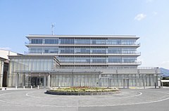
Yamaga (jap. 山鹿市 Yamaga-shi) – miasto w Japonii, w prefekturze Kumamoto, w północnej części wyspy Kiusiu.
Media użyte na tej stronie
Autor: Maximilian Dörrbecker (Chumwa), Licencja: CC BY-SA 3.0
Location map of Japan
Equirectangular projection.
Geographic limits to locate objects in the main map with the main islands:
- N: 45°51'37" N (45.86°N)
- S: 30°01'13" N (30.02°N)
- W: 128°14'24" E (128.24°E)
- E: 149°16'13" E (149.27°E)
Geographic limits to locate objects in the side map with the Ryukyu Islands:
- N: 39°32'25" N (39.54°N)
- S: 23°42'36" N (23.71°N)
- W: 110°25'49" E (110.43°E)
- E: 131°26'25" E (131.44°E)
(c) User: (WT-shared) NY066 z wts wikipodróże, CC BY-SA 3.0
Yamaga-Lantern-Museum (Former Yasuda Bank Yamaga Branch), Yamaga, Kumamoto prefecture
Flag of Yamaga, Kumamoto http://www.city.yamaga.kumamoto.jp/reiki/reiki_honbun/ar08106901.html


