Yarra
| ||
 Widok na rzekę z mostu Kanes Bridge | ||
| Kontynent | Australia | |
| Państwo | ||
| Stan | ||
| Rzeka | ||
| Długość | ok. 242 km | |
| Źródło | ||
| Miejsce | góry Yarra | |
| Współrzędne | 37°43′00″S 146°09′00″E/-37,716667 146,150000 | |
| Ujście | ||
| Współrzędne | 37°51′00″S 144°55′00″E/-37,850000 144,916667 | |
Yarra – rzeka w południowej części stanu Wiktoria w Australii. Pierwotna nazwa rzeki nadana przez Aborygenów brzmiała Birrarung.
Rzeka ma swoje źródło w górach Yarra (ang. Yarra Ranges), a w dolnym biegu rzeka płynie przez centralną część miasta Melbourne i uchodzi do zatoki Port Phillip. Rzeka Yarra ma około 242 km długości. Jest najbardziej na zachód położoną rzeką w Australii zasilaną wodami z topniejącego śniegu.
Media użyte na tej stronie
Autor: , Licencja: CC BY-SA 3.0
Relief map of Australia, including the borders of the states of the Commonwealth of Australia
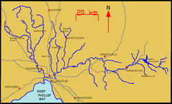
Map of Yarra River and its tributaries.
State flag and government ensign (internal waters only) of Victoria.
Autor: me (w:User:pfctdayelise), Licencja: CC BY-SA 2.5
The Yarra River, in Melbourne, Australia, as seen from Kanes Bridge. Very near to the Yarra River Trail (for cyclists).
Autor: Diliff, Licencja: CC BY 2.5
The Yarra River flowing past the Royal Botanical Gardens on the left and towards Birrarung Marr on the right on its way through the CBD. Taken with a Canon 5D and 24-105mm F/4L IS lens on the 23rd of October, 2005 by myself.
Autor:
- Australia_Victoria_location_map.svg: NordNordWest
- derivative work: Uwe Dedering (talk)
Location map of Victoria, Australia


