Yellowstone (jezioro)
| ||
 Widok na jezioro | ||
| Położenie | ||
| Państwo | ||
| Stan | ||
| Lokalizacja | Park Narodowy Yellowstone | |
| Region | Góry Skaliste | |
| Wysokość lustra | 2358[1] m n.p.m. | |
| Wyspy | 6 (Frank, Stevenson, Dot, Peale, Carrington, Molly Islands) | |
| Morfometria | ||
| Powierzchnia | 350 km² | |
| Wymiary • max długość • max szerokość | 32 km 24 km | |
| Głębokość • średnia • maksymalna | 42 m 120 m | |
| Długość linii brzegowej | 177km | |
| Objętość | 14,87 km³ | |
| Hydrologia | ||
| Rzeki zasilające | Yellowstone, Pelican Creek, Clear Creek, Beaverdam Creek, Columbine Creek | |
| Rzeki wypływające | Yellowstone, | |
Yellowstone (ang. Yellowstone Lake) – największe jezioro w Parku Narodowym Yellowstone w stanie Wyoming (USA), o głębokości średniej 42 m (w najgłębszym miejscu 118 m). Jezioro znajduje się na wysokości 2376 m n.p.m. i po jeziorze Titicaca jest drugim najwyżej położonym słodkowodnym jeziorem na Ziemi.
Inne nazwy jeziora to Bridger Lake, Lake Riddle i Sublette Lake[1].
Bibliografia
Don and Barbara Laine: Frommer's national parks of the American West. Hoboken: Wiley Publishing, Inc., 2010. ISBN 978-0-470-53767-1.
Przypisy
- ↑ a b Feature Detail Report for: Yellowstone Lake (ang.). The Geographic Names Information System (GNIS). [dostęp 2018-06-15].
Media użyte na tej stronie
Autor: Uwe Dedering, Licencja: CC BY-SA 3.0
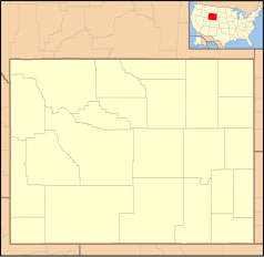
Relief location map of the USA (without Hawaii and Alaska).
EquiDistantConicProjection : Central parallel :
* N: 37.0° N
Central meridian :
* E: 96.0° W
Standard parallels:
* 1: 32.0° N
* 2: 42.0° N
Made with Natural Earth. Free vector and raster map data @ naturalearthdata.com.
Formulas for x and y:
x = 50.0 + 124.03149777329222 * ((1.9694462586094064-({{{2}}}* pi / 180))
      * sin(0.6010514667026994 * ({{{3}}} + 96) * pi / 180))
y = 50.0 + 1.6155950752393982 * 124.03149777329222 * 0.02613325650382181
      - 1.6155950752393982  * 124.03149777329222 *
     (1.3236744353715044  - (1.9694462586094064-({{{2}}}* pi / 180))
      * cos(0.6010514667026994 * ({{{3}}} + 96) * pi / 180))
The flag of Navassa Island is simply the United States flag. It does not have a "local" flag or "unofficial" flag; it is an uninhabited island. The version with a profile view was based on Flags of the World and as a fictional design has no status warranting a place on any Wiki. It was made up by a random person with no connection to the island, it has never flown on the island, and it has never received any sort of recognition or validation by any authority. The person quoted on that page has no authority to bestow a flag, "unofficial" or otherwise, on the island.
Autor: Tzugaj, Licencja: CC0
znak graficzny do map, ukazujący przykładowe jezioro
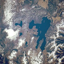
Yellowstone National Park, the largest national park in the United States, and Yellowstone Lake, the largest high-mountain lake in North America [139 square miles (360 square kilometers)], are featured in this west-southwest-looking, low-oblique photograph. The park lies atop a massive, dish-shaped, volcanic caldera approximately 30 miles (48 kilometers) by 45 miles (72 kilometers) in size. The caldera was partially filled by lava that flowed from the cracks and opening floor after the massive eruption and collapse of the volcano approximately 600 000 years ago—an eruption 1000 times the force of the 1980 eruption of Mount Saint Helens Volcano in Washington. With approximately 10 000 geysers and hot springs, Yellowstone sits on one of the hottest "hot spots" on Earth. Between 1923 and 1985, the caldera rose almost 4 feet (1 meter) in height. Since 1985, the caldera has sunk approximately 6 inches (15 centimeters). Visible are portions of the volcanic Absaroka Range to the east and three smaller lakes near Yellowstone Lake—Shoshone, to the southwest; Lewis, southeast of Shoshone; and Heart Lake, the smallest and most southeastern.
Ta ^specifik^ z W3C grafika wektorowa została stworzona za pomocą Inkscape.
Autor: Eeekster, Licencja: CC BY 3.0
Yellowstone Lake, Yellowstone National Park


