Yerres
| miejscowość i gmina | |||
 | |||
| |||
| Państwo | |||
|---|---|---|---|
| Region | |||
| Departament | |||
| Okręg | |||
| Kod INSEE | 91691 | ||
| Burmistrz | Olivier Clodong | ||
| Powierzchnia | 9,84 km² | ||
| Populacja (2018) • liczba ludności |
| ||
| • gęstość | 3002 os./km² | ||
| Kod pocztowy | 91330 | ||
| Strefa czasowa | UTC + 1 | ||
Położenie na mapie Île-de-France (c) Eric Gaba, Wikimedia Commons user Sting, CC BY-SA 3.0 | |||
| Portal | |||
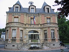
Yerres – miejscowość i gmina we Francji, w regionie Île-de-France, w departamencie Essonne.
Według danych na rok 2018 gminę zamieszkiwało 29 546 osób[1], a gęstość zaludnienia wynosiła 3002 osób/km² (wśród 1287 gmin regionu Île-de-France Yerres plasuje się na 93. miejscu pod względem liczby ludności, natomiast pod względem powierzchni na miejscu 389.).
Geografia
Yerres leży w północno – wschodniej części Essonne na granicy z departamentem Val-de-Marne. Miejscowość leży w dolinie przez, którą przepływa rzeka Yerres. Najwyższym punktem jest Mont Griffon (115 m n.p.m)[2].
Demografia
Ludność według grup wiekowych[3]:
| Wiek | 2007 | % | 2012 | % | 2017 | % |
|---|---|---|---|---|---|---|
| 0 - 14 lat | 5445 | 18,9 | 5511 | 19,1 | 5844 | 20,1 |
| 15 - 29 lat | 5212 | 18,1 | 4973 | 17,3 | 4751 | 16,4 |
| 30 - 44 lat | 6430 | 22,3 | 6141 | 21,3 | 6024 | 20,8 |
| 45 - 59 lat | 6176 | 21,5 | 5720 | 19,9 | 5927 | 20,4 |
| 60 - 74 lat | 3718 | 12,9 | 4219 | 14,7 | 4297 | 14,8 |
| 75 lat i więcej | 1806 | 6,3 | 2219 | 7,7 | 2186 | 7,5 |
Ludność historyczna[3]:
| Rok | 1982 | 1990 | 1999 | 2007 | 2012 | 2017 |
|---|---|---|---|---|---|---|
| Populacja | 25715 | 27136 | 27455 | 28789 | 28784 | 29029 |
| Średnia gęstość (mieszk. / Km²) | 2613,3 | 2757,7 | 2790,1 | 2925,7 | 2925,2 | 2950,1 |
Transport
Przez Yerres przebiega linia RER D.
Miasta partnerskie
Przypisy
- ↑ Populations légales 2018 − Ces données sont disponibles sur toutes les communes de France hors Mayotte | Insee, www.insee.fr [dostęp 2021-04-12].
- ↑ {{{tytuł}}}, www.yerres.fr [dostęp 2021-04-12].
- ↑ a b Dossier complet − Commune d'Yerres (91691) | Insee, www.insee.fr [dostęp 2021-04-12].
Bibliografia
- Francuski urząd statystyczny (fr.).
Linki zewnętrzne
Media użyte na tej stronie
Autor: Superbenjamin, Licencja: CC BY-SA 4.0
Blank administrative map of France for geo-location purpose, with regions and departements distinguished. Approximate scale : 1:3,000,000
(c) Eric Gaba, Wikimedia Commons user Sting, CC BY-SA 3.0
Blank administrative map of the region of Île-de-France, France, as in January 2015, for geo-location purpose, with distinct boundaries for regions, departments and arrondissements.
Autor: Heralder, Licencja: CC BY-SA 3.0
Coat of arms of the French Commune of Yerres
Autor: Eric Gaba (Sting - fr:Sting), Licencja: CC BY-SA 3.0
Blank administrative map of the department of Essonne, France, for geo-location purpose, with distinct boundaries for regions, departments and arrondissements.


