Yorkshire Dales
 Wjazd na teren parku narodowego Yorkshire Dales | |
| park narodowy | |
| Państwo | |
|---|---|
| Kraj | |
| Położenie | |
| Data utworzenia | 1954 |
| Powierzchnia | 2179 km² |
 (c) Wikishire, CC BY-SA 4.0 Mapa parku narodowego Yorkshire Dales | |
Położenie na mapie Anglii  | |
Położenie na mapie Wielkiej Brytanii  | |
Yorkshire Dales (z ang. „doliny Yorkshire”) – wyżynny obszar w północnej Anglii, w północnej części historycznego hrabstwa Yorkshire.
Yorkshire Dales obejmuje liczne doliny rzeczne oraz wzniesienia pomiędzy nimi, położone między doliną Vale of York na wschodzie a Górami Pennińskimi na zachodzie.
Znaczna część obszaru objęta jest ochroną w ramach parku narodowego Yorkshire Dales, który utworzony został w 1954 roku. Powierzchnia parku wynosi 2179 km² (w 2016 roku powiększona z 1762 km²) i znajduje się na terenie trzech hrabstw: North Yorkshire, Kumbria i Lancashire[1].
Główne doliny
- Arkengarthdale
- Birkdale
- Bishopdale
- Coverdale
- Dentdale
- Garsdale
- Langstrothdale
- Littondale
- Malhamdale
- Nidderdale
- Ribblesdale
- Swaledale
- Wensleydale
- Wharfedale
- Krajobrazy parku narodowego Yorkshire Dales
Tan Hill Inn (w tle), najwyżej położony pub w Wielkiej Brytanii

Pastwiska nieopodal Whaw

Ścieżka wzdłuż Fremington Edge

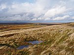
Ścieżka w kierunku East Bolton Moor
Przypisy
- ↑ The Yorkshire Dales National Park is being extended! (ang.). Yorkshire Dales National Park.
Bibliografia
- Yorkshire Dales National Park Authority (ang.). [dostęp 2010-02-08].
- The Yorkshire Dales Society (ang.). [dostęp 2010-02-08]. [zarchiwizowane z tego adresu (2006-08-10)].
Media użyte na tej stronie


Flag of England. Saint George's cross (a red cross on a white background), used as the Flag of England, the Italian city of Genoa and various other places.

Shiny green button/marker widget.
Autor: Kreuzschnabel, Licencja: CC BY-SA 3.0
B 6270 crossing the border of Cumbria into North Yorkshire between Nateby and Keld

Autor: Kreuzschnabel, Licencja: CC BY-SA 3.0
Characteristic appearance of the Yorkshire Dales: pastures below, moorland above. Taken near Whaw in Arkengarthdale.

Autor: Kreuzschnabel, Licencja: CC BY-SA 3.0
Approaching Tan Hill Inn on the Pennine Way from the south

Autor: Kreuzschnabel, Licencja: CC BY-SA 3.0
Walking towards East Bolton Moor, Yorkshire Dales

Autor: Kreuzschnabel, Licencja: CC BY-SA 3.0
Rough track leading from Fremington Edge towards Marrick on a sunny autumn afternoon
Autor: Alexrk2, Licencja: CC BY-SA 3.0
Location map of the United Kingdom
Autor: Nilfanion, Licencja: CC BY-SA 3.0
Relief map of England, UK.
Equirectangular map projection on WGS 84 datum, with N/S stretched 170%
Geographic limits:
- West: 6.75W
- East: 2.0E
- North: 56.0N
- South: 49.75N
(c) Wikishire, CC BY-SA 4.0
Map of the Yorkshire Dales National Park as extended on 1 August 2016, in the North and West Ridings of Yorkshire and in Westmorland