Złota linia metra w Los Angeles
_of_the_Los_Angeles_County_Metro_System.png) | ||||||||||||||||||||||||||||||||||||||||||||||||||||||||||||||||||||||||||||||||||||||||||||||||||||||||||||||||||||||||||||||||||||||||||||||||||||||||||||||||||||||||||||||||||||||||||||||||||||||||||||||||||||||||||||||||||||||||||||||||||||||||||||||||||||||||||||||||||||||||||||||||||||||||||||||||||||||||||||||||||||||||||||||||||||||||||||||||||||||||||||||||||||||||||||||||||||||||||||||||||||||||||||||||||||||||||||||||||||||||||||||||||||||||||||||||||||||||||||||||||||||||||||||||||||||||||||||||||
| Dane podstawowe | ||||||||||||||||||||||||||||||||||||||||||||||||||||||||||||||||||||||||||||||||||||||||||||||||||||||||||||||||||||||||||||||||||||||||||||||||||||||||||||||||||||||||||||||||||||||||||||||||||||||||||||||||||||||||||||||||||||||||||||||||||||||||||||||||||||||||||||||||||||||||||||||||||||||||||||||||||||||||||||||||||||||||||||||||||||||||||||||||||||||||||||||||||||||||||||||||||||||||||||||||||||||||||||||||||||||||||||||||||||||||||||||||||||||||||||||||||||||||||||||||||||||||||||||||||||||||||||||||||
| Zarządca | Los Angeles County Metro Rail Authority | |||||||||||||||||||||||||||||||||||||||||||||||||||||||||||||||||||||||||||||||||||||||||||||||||||||||||||||||||||||||||||||||||||||||||||||||||||||||||||||||||||||||||||||||||||||||||||||||||||||||||||||||||||||||||||||||||||||||||||||||||||||||||||||||||||||||||||||||||||||||||||||||||||||||||||||||||||||||||||||||||||||||||||||||||||||||||||||||||||||||||||||||||||||||||||||||||||||||||||||||||||||||||||||||||||||||||||||||||||||||||||||||||||||||||||||||||||||||||||||||||||||||||||||||||||||||||||||||||
|---|---|---|---|---|---|---|---|---|---|---|---|---|---|---|---|---|---|---|---|---|---|---|---|---|---|---|---|---|---|---|---|---|---|---|---|---|---|---|---|---|---|---|---|---|---|---|---|---|---|---|---|---|---|---|---|---|---|---|---|---|---|---|---|---|---|---|---|---|---|---|---|---|---|---|---|---|---|---|---|---|---|---|---|---|---|---|---|---|---|---|---|---|---|---|---|---|---|---|---|---|---|---|---|---|---|---|---|---|---|---|---|---|---|---|---|---|---|---|---|---|---|---|---|---|---|---|---|---|---|---|---|---|---|---|---|---|---|---|---|---|---|---|---|---|---|---|---|---|---|---|---|---|---|---|---|---|---|---|---|---|---|---|---|---|---|---|---|---|---|---|---|---|---|---|---|---|---|---|---|---|---|---|---|---|---|---|---|---|---|---|---|---|---|---|---|---|---|---|---|---|---|---|---|---|---|---|---|---|---|---|---|---|---|---|---|---|---|---|---|---|---|---|---|---|---|---|---|---|---|---|---|---|---|---|---|---|---|---|---|---|---|---|---|---|---|---|---|---|---|---|---|---|---|---|---|---|---|---|---|---|---|---|---|---|---|---|---|---|---|---|---|---|---|---|---|---|---|---|---|---|---|---|---|---|---|---|---|---|---|---|---|---|---|---|---|---|---|---|---|---|---|---|---|---|---|---|---|---|---|---|---|---|---|---|---|---|---|---|---|---|---|---|---|---|---|---|---|---|---|---|---|---|---|---|---|---|---|---|---|---|---|---|---|---|---|---|---|---|---|---|---|---|---|---|---|---|---|---|---|---|---|---|---|---|---|---|---|---|---|---|---|---|---|---|---|---|---|---|---|---|---|---|---|---|---|---|---|---|---|---|---|---|---|---|---|---|---|---|---|---|---|---|---|---|---|---|---|---|---|---|---|---|---|---|---|---|---|---|---|---|---|---|---|---|---|---|---|---|---|---|---|---|---|---|---|---|---|---|---|---|---|---|---|---|---|---|---|---|---|---|---|---|---|---|---|---|---|---|---|---|---|---|---|---|---|---|---|---|---|---|---|---|---|---|---|---|---|---|---|---|---|---|---|---|---|---|---|---|---|---|---|---|---|---|---|---|---|---|---|---|---|---|---|---|---|---|---|---|---|---|---|---|---|---|
| Oznaczenie linii | 804 | |||||||||||||||||||||||||||||||||||||||||||||||||||||||||||||||||||||||||||||||||||||||||||||||||||||||||||||||||||||||||||||||||||||||||||||||||||||||||||||||||||||||||||||||||||||||||||||||||||||||||||||||||||||||||||||||||||||||||||||||||||||||||||||||||||||||||||||||||||||||||||||||||||||||||||||||||||||||||||||||||||||||||||||||||||||||||||||||||||||||||||||||||||||||||||||||||||||||||||||||||||||||||||||||||||||||||||||||||||||||||||||||||||||||||||||||||||||||||||||||||||||||||||||||||||||||||||||||||
| Liczba pasażerów | ||||||||||||||||||||||||||||||||||||||||||||||||||||||||||||||||||||||||||||||||||||||||||||||||||||||||||||||||||||||||||||||||||||||||||||||||||||||||||||||||||||||||||||||||||||||||||||||||||||||||||||||||||||||||||||||||||||||||||||||||||||||||||||||||||||||||||||||||||||||||||||||||||||||||||||||||||||||||||||||||||||||||||||||||||||||||||||||||||||||||||||||||||||||||||||||||||||||||||||||||||||||||||||||||||||||||||||||||||||||||||||||||||||||||||||||||||||||||||||||||||||||||||||||||||||||||||||||||||
| Liczba stacji | 21 | |||||||||||||||||||||||||||||||||||||||||||||||||||||||||||||||||||||||||||||||||||||||||||||||||||||||||||||||||||||||||||||||||||||||||||||||||||||||||||||||||||||||||||||||||||||||||||||||||||||||||||||||||||||||||||||||||||||||||||||||||||||||||||||||||||||||||||||||||||||||||||||||||||||||||||||||||||||||||||||||||||||||||||||||||||||||||||||||||||||||||||||||||||||||||||||||||||||||||||||||||||||||||||||||||||||||||||||||||||||||||||||||||||||||||||||||||||||||||||||||||||||||||||||||||||||||||||||||||
| Długość | 31,7 km | |||||||||||||||||||||||||||||||||||||||||||||||||||||||||||||||||||||||||||||||||||||||||||||||||||||||||||||||||||||||||||||||||||||||||||||||||||||||||||||||||||||||||||||||||||||||||||||||||||||||||||||||||||||||||||||||||||||||||||||||||||||||||||||||||||||||||||||||||||||||||||||||||||||||||||||||||||||||||||||||||||||||||||||||||||||||||||||||||||||||||||||||||||||||||||||||||||||||||||||||||||||||||||||||||||||||||||||||||||||||||||||||||||||||||||||||||||||||||||||||||||||||||||||||||||||||||||||||||
| Rozstaw szyn | 1435 mm | |||||||||||||||||||||||||||||||||||||||||||||||||||||||||||||||||||||||||||||||||||||||||||||||||||||||||||||||||||||||||||||||||||||||||||||||||||||||||||||||||||||||||||||||||||||||||||||||||||||||||||||||||||||||||||||||||||||||||||||||||||||||||||||||||||||||||||||||||||||||||||||||||||||||||||||||||||||||||||||||||||||||||||||||||||||||||||||||||||||||||||||||||||||||||||||||||||||||||||||||||||||||||||||||||||||||||||||||||||||||||||||||||||||||||||||||||||||||||||||||||||||||||||||||||||||||||||||||||
| Sieć trakcyjna | 750 V | |||||||||||||||||||||||||||||||||||||||||||||||||||||||||||||||||||||||||||||||||||||||||||||||||||||||||||||||||||||||||||||||||||||||||||||||||||||||||||||||||||||||||||||||||||||||||||||||||||||||||||||||||||||||||||||||||||||||||||||||||||||||||||||||||||||||||||||||||||||||||||||||||||||||||||||||||||||||||||||||||||||||||||||||||||||||||||||||||||||||||||||||||||||||||||||||||||||||||||||||||||||||||||||||||||||||||||||||||||||||||||||||||||||||||||||||||||||||||||||||||||||||||||||||||||||||||||||||||
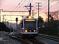
 Tramwaj marki AnsaldoBreda w składzie dwuwagonowym obsługujący złotą linię na stacji Atlantic. | ||||||||||||||||||||||||||||||||||||||||||||||||||||||||||||||||||||||||||||||||||||||||||||||||||||||||||||||||||||||||||||||||||||||||||||||||||||||||||||||||||||||||||||||||||||||||||||||||||||||||||||||||||||||||||||||||||||||||||||||||||||||||||||||||||||||||||||||||||||||||||||||||||||||||||||||||||||||||||||||||||||||||||||||||||||||||||||||||||||||||||||||||||||||||||||||||||||||||||||||||||||||||||||||||||||||||||||||||||||||||||||||||||||||||||||||||||||||||||||||||||||||||||||||||||||||||||||||||||
| Historia | ||||||||||||||||||||||||||||||||||||||||||||||||||||||||||||||||||||||||||||||||||||||||||||||||||||||||||||||||||||||||||||||||||||||||||||||||||||||||||||||||||||||||||||||||||||||||||||||||||||||||||||||||||||||||||||||||||||||||||||||||||||||||||||||||||||||||||||||||||||||||||||||||||||||||||||||||||||||||||||||||||||||||||||||||||||||||||||||||||||||||||||||||||||||||||||||||||||||||||||||||||||||||||||||||||||||||||||||||||||||||||||||||||||||||||||||||||||||||||||||||||||||||||||||||||||||||||||||||||
| Lata budowy | 2003 – 2016 | |||||||||||||||||||||||||||||||||||||||||||||||||||||||||||||||||||||||||||||||||||||||||||||||||||||||||||||||||||||||||||||||||||||||||||||||||||||||||||||||||||||||||||||||||||||||||||||||||||||||||||||||||||||||||||||||||||||||||||||||||||||||||||||||||||||||||||||||||||||||||||||||||||||||||||||||||||||||||||||||||||||||||||||||||||||||||||||||||||||||||||||||||||||||||||||||||||||||||||||||||||||||||||||||||||||||||||||||||||||||||||||||||||||||||||||||||||||||||||||||||||||||||||||||||||||||||||||||||
| Rok otwarcia | 26 lipca 2003 | |||||||||||||||||||||||||||||||||||||||||||||||||||||||||||||||||||||||||||||||||||||||||||||||||||||||||||||||||||||||||||||||||||||||||||||||||||||||||||||||||||||||||||||||||||||||||||||||||||||||||||||||||||||||||||||||||||||||||||||||||||||||||||||||||||||||||||||||||||||||||||||||||||||||||||||||||||||||||||||||||||||||||||||||||||||||||||||||||||||||||||||||||||||||||||||||||||||||||||||||||||||||||||||||||||||||||||||||||||||||||||||||||||||||||||||||||||||||||||||||||||||||||||||||||||||||||||||||||
| ||||||||||||||||||||||||||||||||||||||||||||||||||||||||||||||||||||||||||||||||||||||||||||||||||||||||||||||||||||||||||||||||||||||||||||||||||||||||||||||||||||||||||||||||||||||||||||||||||||||||||||||||||||||||||||||||||||||||||||||||||||||||||||||||||||||||||||||||||||||||||||||||||||||||||||||||||||||||||||||||||||||||||||||||||||||||||||||||||||||||||||||||||||||||||||||||||||||||||||||||||||||||||||||||||||||||||||||||||||||||||||||||||||||||||||||||||||||||||||||||||||||||||||||||||||||||||||||||||
| Portal | ||||||||||||||||||||||||||||||||||||||||||||||||||||||||||||||||||||||||||||||||||||||||||||||||||||||||||||||||||||||||||||||||||||||||||||||||||||||||||||||||||||||||||||||||||||||||||||||||||||||||||||||||||||||||||||||||||||||||||||||||||||||||||||||||||||||||||||||||||||||||||||||||||||||||||||||||||||||||||||||||||||||||||||||||||||||||||||||||||||||||||||||||||||||||||||||||||||||||||||||||||||||||||||||||||||||||||||||||||||||||||||||||||||||||||||||||||||||||||||||||||||||||||||||||||||||||||||||||||
Złota linia metra w Los Angeles – linia metra jedynie w potocznym znaczeniu tego słowa, gdyż w zasadzie jest to naziemna linia lekkiej kolei miejskiej mająca na swej trasie cztery odcinki podziemne. Złota linia łączy miasto Azusę z osadą East Los Angeles.
Godziny kursowania
Tramwaje linii złotej kursują w przybliżeniu pomiędzy godziną 3 a 2 w nocy[3]
Pierwszy tramwaj odjeżdża w kierunku APU/Citrus College ze stacji Atlantic o 4:17 (o 4:20 odjeżdża w soboty, niedziele i święta)
Ostatni tramwaj odjeżdża w kierunku APU/Citrus College ze stacji Atlantic o 2:12
Pierwszy tramwaj odjeżdża w kierunku Atlantic ze stacji APU/Citrus College o 3:45
Ostatni tramwaj odjeżdża w kierunku Atlantic ze stacji APU Citrus College o 2:08 i kończy bieg na stacji Little Tokyo/Arts District
Lista stacji
Złota linia składa się z następujących stacji (z południa na północ).
| Stacja | Połączenia | Data otwarcia | Miasto/Dzielnica |
|---|---|---|---|
| Atlantic | Metro Local: 260 Metro Rapid: 762 Montebello Transit: 10, 40, 341, 342 El Sol: City Terrace/ELAC, Whittier Blvd/Saybrook Park | 15 listopada 2009 | East Los Angeles |
| East L.A. Civic Center | Metro Local: 258 Montebello Transit:40 El Sol: City Terrace/ELAC, Union Pacific/Salazar Park, Whittier Blvd/Saybrook Park | ||
| Maravilla | Metro Local: 256 Montebello Transit: 40 El Sol: Union Pacific/Salazar Park, Whittier Blvd/Saybrook Park | ||
| Indiana | Metro Local: 30, 68 Shuttle (kursuje codziennie), 254, 620, 665 Montebello Transit: 40 Whittier Blvd/Saybrook Park | ||
| Soto | Metro Local: 30, 251, 252, 605 Metro Rapid: 751 | Los Angeles (Boyle Heights) | |
| Mariachi Plaza | Metro Local: 30, 620 | ||
| Pico/Aliso | Metro Local: 30 | ||
| Little Tokyo/Arts District | Metro Local: 30, 40, 330 LADOT DASH: A, D | Los Angeles (Little Tokyo/Arts District) | |
| Union Station | Czerwona linia Fioletowa linia Srebrna linia BRT Metro Local: 40, 68, 70, 71, 78, 79 Metro Express: 442, 485, 487 Metro Rapid: 704, 728, 733, 745, 770 Amtrak Big Blue Bus: Rapid 10 FlyAway Foothill Transit: Silver Streak LADOT DASH: B, D, Lincoln Heights/Chinatown Metrolink | 26 lipca 2003 | Downtown Los Angeles |
| Chinatown | Metro Local: 45, 76, 81, 83, 84, 90, 91, 94, 96 Metro Rapid: 794 LADOT DASH: B, Lincoln Heights/Chinatown LADOT Commuter Express: 409, 419 | ||
| Lincoln/Cypress | Metro Local:81, 84, 90, 91, 94, 251 Metro Rapid: 751, 794 | ||
| Heritage Square/Arroyo | Metro Local: 81, 83 | ||
| Southwest Museum | Metro Local: 81, 83 | ||
| Highland Park | Metro Local: 81, 83, 256 LADOT DASH: Highland Park/Eagle Rock | ||
| South Pasadena | Metro Local: 176 | South Pasadena | |
| Fillmore | Metro Local: 260, 686, 687 Metro Rapid: 762 Pasadena Transit: 20[4] | Pasadena | |
| Del Mar | Metro Local: 177, 256, 260, 686, 687 Metro Express: 501 | ||
| Memorial Park | Metro Local: 180, 181, 256, 260, 267, 686, 687 Metro Express: 501 Metro Rapid: 762, 780 Pasadena Transit: 10 | ||
| Lake | Metro Local: 180 Metro Express: 485 | ||
| Allen | Metro Local: 256, 686 Pasadena Transit: 10 | ||
| Sierra Madre Villa | Metro Local: 181, 264, 266, 268 Metro Express: 487 Foothill Transit: 187 Pasadena Transit: 31 | ||
| Arcadia | Metro Local: 79, 487 Foothill Transit: 187 Arcadia Transit | 5 marca 2016 | Arcadia |
| Monrovia | Metro Local: 264, 270 Foothill Transit: 494 | Monrovia | |
| Duarte/City of Hope | Metro Local: 264, 270 Foothill Transit: 272 Duarte Transit: Green, Blue | Duarte | |
| Irwindale | Foothill Transit: 185 | Irwindale | |
| Azusa Downtown | Foothill Transit: 185, 187, 280, 494, 496 | Azusa | |
| APU Citrus College | Foothill Transit: 187, 281, 284, 488 |
Pociąg złotej linii metra jadący przez miasto South Pasadena
Stacja Memorial Park znajduje się w Pasadenie pod apartamentowcem Holy Street Apartments
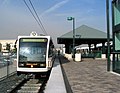
Pociąg złotej linii na peronie Union Station

Przejazd ze szlabanami na skrzyżowaniu W Avenue 33 z Atresian Street położonego na północny wschód od stacji metra Lincoln Heights / Cypress Park
Przypisy
- ↑ Ridership Statistics, www.metro.net [dostęp 2017-11-20] [zarchiwizowane z adresu 2012-07-01] (ang.).
- ↑ http://media.metro.net/news_info/images/ridership_graphs.pdf
- ↑ Zarchiwizowana kopia. [dostęp 2013-06-25]. [zarchiwizowane z tego adresu (2013-06-25)].
- ↑ Zarchiwizowana kopia. [dostęp 2016-05-28]. [zarchiwizowane z tego adresu (2016-10-06)].
Linki zewnętrzne
- Strona domowa MTA
- Rozkład jazdy złotej linii. metro.net. [zarchiwizowane z tego adresu (2013-06-25)].
| Usługi Metro |
| ||||||
|---|---|---|---|---|---|---|---|
| Wyposażenie i stacje |
| ||||||
| Główne projekty |
| ||||||
| Inne informacje |
|

Media użyte na tej stronie


underground train station (legend icon)

ex underground train station (legend icon)


underground train stop (legend icon)

ex underground train stop (legend icon)


underground service station (legend icon)

ex underground service station (legend icon)

non-passenger stop (legend icon)

ex non-passenger stop (legend icon)

underground service stop (legend icon)

ex underground service stop (legend icon)


local-only minor station

Icons for railway description

out-of-use local-only minor metro station


Railroad BSicon


Underground straight track

ex underground straight track


straight line, modified version (+ex, +t, +ext)

underground tunnel straight track

ex underground tunnel straight track

high level track

ex high level track

underground high level track

ex underground high level track

Bridge (big)

Bridge (big)


BS template transport icon

bridge over water straight (big)

bridge over water straight (big)


for BS models. water tunnel, urban(blue), not in use.

mileage change

ex mileage change

A mile-marker for metros/canals

mileage change


Border icon

Track change (new design)

track change (new design)

Track switch, metro/light rail

track change, metro/light rail (new design)

level crossing straight

Disused railway line level crossing on minor road.

underground level crossing straight

Ex underground level crossing straight


Autor: Lekko gazowany, Licencja: CC BY-SA 3.0
electrified line start sign for railways


Autor: Lekko gazowany, Licencja: CC BY-SA 3.0
electrified line end sign for railways

.svg)
28 in by 24 in (711 mm by 610 mm) California-style U.S. Route shield, made to the specifications of the 2002 edition of Standard Highway Signs with 10 in (250 mm) numerals. Uses the Roadgeek fonts. (United States law does not permit the copyrighting of typeface designs, and the fonts are meant to be copies of a U.S. Government-produced work anyway.)

Autor: Created 2007, by Ricky Courtney, please credit., Licencja: CC BY 2.0
Map of the Gold Line, including future extensions, in Los Angeles County, California.

Open stations on cut-and-cover underground routes
.svg)
25 in by 30 in (635 mm by 762 mm) Interstate shield, made to the specifications of the 1971 Caltrans sign drawing (still in use). Uses the Roadgeek 2005 fonts. (United States law does not permit the copyrighting of typeface designs, and the fonts are meant to be copies of a U.S. Government-produced work anyway.) Colors are from [1] (Pantone Red 187 and Blue 294), converted to RGB by [2]. The outside border has a width of 1 and a color of black so it shows up; in reality, signs have no outside border.

Autor: Craigdietrich, Licencja: CC BY 3.0
A Los Angeles Metro Gold Line train crosses W Avenue 33 at Artesian St with gates down, northeast of Lincoln Heights / Cypress Park Station

Red Line circle.

Icon for railroad diagram
.svg)
24 in by 24 in (600 mm by 600 mm) Interstate shield, made to the specifications of the 1971 Caltrans sign drawing (still in use). Uses the Roadgeek 2005 fonts. (United States law does not permit the copyrighting of typeface designs, and the fonts are meant to be copies of a U.S. Government-produced work anyway.) Colors are from the MUTCD Color Specifications (Pantone Red 187 and Blue 294), converted to RGB by [1]. The outside border has a width of 1 and a color of black so it shows up; in reality, signs have no outside border.
.svg)
25 in by 30 in (635 mm by 762 mm) Interstate shield, made to the specifications of the 1971 Caltrans sign drawing (still in use). Uses the Roadgeek 2005 fonts. (United States law does not permit the copyrighting of typeface designs, and the fonts are meant to be copies of a U.S. Government-produced work anyway.) Colors are from [1] (Pantone Red 187 and Blue 294), converted to RGB by [2]. The outside border has a width of 1 and a color of black so it shows up; in reality, signs have no outside border.

Underground tunnel terminal station

Underground terminal station

Silver Line square (for Los Angeles Metro).
.svg)
25 in by 30 in (635 mm by 762 mm) Interstate shield, made to the specifications of the 1971 Caltrans sign drawing (still in use). Uses the Roadgeek 2005 fonts. (United States law does not permit the copyrighting of typeface designs, and the fonts are meant to be copies of a U.S. Government-produced work anyway.) Colors are from [1] (Pantone Red 187 and Blue 294), converted to RGB by [2]. The outside border has a width of 1 and a color of black so it shows up; in reality, signs have no outside border.

Urban metro junction with (unused) branches to and from the left.

Autor: Oryginalnym przesyłającym był DaveofCali z angielskiej Wikipedii, Licencja: CC BY 2.0
Gold Line train platform at Union Station
Photo taken by user DaveofCali (David Liu)


Vector image of a 24 in by 25 in (600 mm by 635 mm) California State Route shield. Colors are from [1] (Pantone Green 342), converted to RGB by [2]. The outside border has a width of 1 (1/16 in) and a color of black so it shows up; in reality, signs have no outside border.

(c) DaveofCali z angielskojęzycznej Wikipedii, CC-BY-SA-3.0
Passengers at the Memorial Park Station in Pasadena await as a Gold Line train approaches the platform


Purple Line circle.

motorway under water


Gold Line circle.

light railway end of elevated track

Unused continuation forward, rotated across, set "u"

Vector image of a 24 in by 25 in (600 mm by 635 mm) California State Route shield. Colors are from [1] (Pantone Green 342), converted to RGB by [2]. The outside border has a width of 1 (1/16 in) and a color of black so it shows up; in reality, signs have no outside border.

underground mixed crossing high level
(c) The Port of Authority & Cian Ginty, CC BY-SA 3.0
An example of the different types of services Metro provides. From top-left clockwise: light rail, bus, bus rapid transit, and rapid transit (subway).

LACMTA Gold Line in the Arroyo Seco - at South Pasadena.
- photos and descriptions - of South Pasadena Photographer SALAAM ALLAH


BSicon

light railway start of elevated track


subway train icon, based on Toronto Transit Commission design

head station, track starting

Underground terminal station


underground tunnel station


Underground station
Autor: METRO96, Licencja: CC BY-SA 3.0
Metro Gold Line docked at Atlantic Station.


junction to left & right

underground high level track over water