Zacatecas (miasto)
| |||||
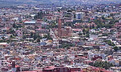
 Panorama miasta | |||||
| |||||
| Państwo | |||||
| Stan | |||||
| Burmistrz | Ulises Mejía Haro (2018–2021) | ||||
| Powierzchnia | 356,14 km² | ||||
| Wysokość | 2460 m n.p.m. | ||||
| Populacja (2015) • liczba ludności • gęstość | 146 147 345,06 os./km² | ||||
| Nr kierunkowy | 492 | ||||
| Kod pocztowy | 98000[1] | ||||
| Strona internetowa | |||||
| ||
| Obiekt z listy światowego dziedzictwa UNESCO | ||
| Państwo | ||
| Typ | kulturowy | |
| Spełniane kryterium | II, IV | |
| Numer ref. | 676 | |
| Historia wpisania na listę | ||
| Wpisanie na listę | 1993 na 17. sesji | |
Zacatecas – miasto w środkowym Meksyku, na Wyżynie Meksykańskiej, stolica stanu Zacatecas.
W 1993 roku historyczne centrum Zacatecas wpisano na listę światowego dziedzictwa UNESCO[2].
Współpraca
 Azusa, Stany Zjednoczone
 El Paso, Stany Zjednoczone
 Malaga, Hiszpania
 Santa Fe, Stany Zjednoczone
 Allahabad, Indie
 Wichita, Stany Zjednoczone
 Norwalk, Stany Zjednoczone
 Gmina Hanover, Stany Zjednoczone
 Memphis, Stany Zjednoczone
Przypisy
- ↑ Código Postal 98000 (hiszp.). worldpostalcodes.org. [dostęp 2020-11-24].
- ↑ Historic Centre of Zacatecas (ang.). whc.unesco.org. [dostęp 2020-11-24].
| ||||||||||||
Media użyte na tej stronie
The flag of Navassa Island is simply the United States flag. It does not have a "local" flag or "unofficial" flag; it is an uninhabited island. The version with a profile view was based on Flags of the World and as a fictional design has no status warranting a place on any Wiki. It was made up by a random person with no connection to the island, it has never flown on the island, and it has never received any sort of recognition or validation by any authority. The person quoted on that page has no authority to bestow a flag, "unofficial" or otherwise, on the island.
Autor: Pedro A. Gracia Fajardo, escudo de Manual de Imagen Institucional de la Administración General del Estado, Licencja: CC0
Flaga Hiszpanii
The Flag of India. The colours are saffron, white and green. The navy blue wheel in the center of the flag has a diameter approximately the width of the white band and is called Ashoka's Dharma Chakra, with 24 spokes (after Ashoka, the Great). Each spoke depicts one hour of the day, portraying the prevalence of righteousness all 24 hours of it.
Flag of the United Nations Educational, Scientific and Cultural Organization (UNESCO)
Flag of Zacatecas.svg
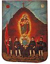
imagen del pendon original otorgado como escudo de armas al la Ciudad de Zacatecas, por Felipe II
Autor: Cvmontuy, Licencja: CC BY-SA 4.0
Our Lady of Fatima Church, Zacatecas city, Zacatecas state, Mexico
(c) EvanProdromou z angielskojęzycznej Wikipedii, CC-BY-SA-3.0
Cathedral in Zacatecas Copyright 2002, Evan Prodromou. Released under the GNU Free Documentation License.
Autor: MikSed, Licencja: CC BY-SA 3.0
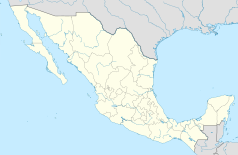
Location Map of Zacatecas Equirectangular projection, Geographic limits of the map:
- N: 25.19° N
- S: 21.00° N
- W: 104.40° W
- E: 100.69° W


