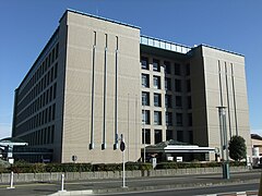
Zama (Japonia)
| |||||||
 Zama City Hall | |||||||
| |||||||
| Państwo | |||||||
|---|---|---|---|---|---|---|---|
| Prefektura | |||||||
| Wyspa | |||||||
| Region | |||||||
| Burmistrz | Mikio Endō (od 01.10.2008) | ||||||
| Powierzchnia | 17,57 km² | ||||||
| Populacja (2015.10.01) • liczba ludności • gęstość |
| ||||||
| Kod pocztowy | 252-8566 | ||||||
| Symbole japońskie | |||||||
| Drzewo | Słodki osmanthus | ||||||
| Kwiat | |||||||
| Ptak | Bogatka wschodnia | ||||||
| Strona internetowa | |||||||
| Portal | |||||||
Zama (jap. 座間市 Zama-shi) – miasto w Japonii, w prefekturze Kanagawa, na wyspie Honsiu, nad rzeką Sagami.
Położenie
Miasto leży w centralnej części prefektury i graniczy z miastami:
Przemysł
W tym mieście rozwinął się przemysł samochodowy, odzieżowy, włókienniczy, papierniczy, spożywczy oraz drzewny.
Historia
1 kwietnia 1889 roku w powiecie Kōza powstała wioska Zama. 20 grudnia 1937 roku wioska zdobyła status miasteczka (町). 29 kwietnia 1941 roku miejscowość stała się częścią Sagamihary, a 1 września 1948 roku odłączyła się i miejscowość została ponownie utworzona. 1 listopada 1971 roku Zama zdobyła status miasta[1][2].
Populacja
Zmiany w populacji Zamy w latach 1970–2015:
| Rok | Populacja |
|---|---|
| 1970 | 56 727 |
| 1975 | 80 562 |
| 1980 | 93 503 |
| 1985 | 100 000 |
| 1990 | 112 102 |
| 1995 | 118 159 |
| 2000 | 125 694 |
| 2005 | 128 174 |
| 2010 | 129 436 |
| 2015 | 128 737 |
Przypisy
- ↑ 1 土地、気象 – 座間市ホームページ (jap.). .city.zama.kanagawa.jp. [dostęp 2018-06-21].
- ↑ 履歴情報 神奈川県 (jap.). uub.jp. [dostęp 2021-01-02].
Miasta partnerskie
Linki zewnętrzne
- Oficjalna strona miasta (jap.)
Media użyte na tej stronie
Autor: ja: 利用者:Lincun, Licencja: CC BY-SA 3.0
Map of Kanagawa Prefecture, Japan.
Autor: Maximilian Dörrbecker (Chumwa), Licencja: CC BY-SA 3.0
Location map of Japan
Equirectangular projection.
Geographic limits to locate objects in the main map with the main islands:
- N: 45°51'37" N (45.86°N)
- S: 30°01'13" N (30.02°N)
- W: 128°14'24" E (128.24°E)
- E: 149°16'13" E (149.27°E)
Geographic limits to locate objects in the side map with the Ryukyu Islands:
- N: 39°32'25" N (39.54°N)
- S: 23°42'36" N (23.71°N)
- W: 110°25'49" E (110.43°E)
- E: 131°26'25" E (131.44°E)
The flag of Navassa Island is simply the United States flag. It does not have a "local" flag or "unofficial" flag; it is an uninhabited island. The version with a profile view was based on Flags of the World and as a fictional design has no status warranting a place on any Wiki. It was made up by a random person with no connection to the island, it has never flown on the island, and it has never received any sort of recognition or validation by any authority. The person quoted on that page has no authority to bestow a flag, "unofficial" or otherwise, on the island.
Autor: Created by LERK, Licencja: Copyrighted free use
The shadow picture of Kanagawa Prefecture, Japan
Flag of Kanagawa Prefecture.
Autor: Mj-bird, Licencja: CC BY-SA 3.0
Zama City Hall, KANAGAWA Pref. Japan
Flag of Zama, Kanagawa
Emblem of Zama, Kanagawa


