Zatoka Spencera
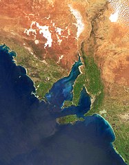
 Zatoka Spencera widziana z kosmosu | |
| Państwo | |
|---|---|
| Stan | |
| Lokalizacja | |
| Wymiary | 322 × 129 (max) km |
| Miejscowości nadbrzeżne | Whyalla, Port Pirie, Port Augusta |
Zatoka Spencera (ang. Spencer Gulf) – zatoka Oceanu Indyjskiego w Australii Południowej.
Zatoka ma 322 km długości i 129 km szerokości w najszerszym miejscu. Zachodni brzeg zatoki stanowi Półwysep Eyrego, a wschodni - półwysep Yorke. Największymi miastami nad zatoką są Whyalla, Port Pirie i Port Augusta.
Zatoka została odkryta w 1802 r. przez Matthew Flindersa, który nadał jej nazwę po George Johnie Spencerze 2, przodku Diany Spencer, księżnej Walii. Brzegi zatoki pierwszy zbadał Edward John Eyre w 1840.
Media użyte na tej stronie
Autor: , Licencja: CC BY-SA 3.0
Relief map of Australia, including the borders of the states of the Commonwealth of Australia
Spencer Gulf seen from NASA Satellites
Autor: Tentotwo, Licencja: CC BY-SA 3.0
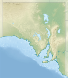
Location map of South Australia, Australia
Equidistant cylindrical projection, latitude of true scale 31.27° S (equivalent to equirectangular projection with N/S stretching 117 %). Geographic limits of the map:
- N: 25.6° S
- S: 38.5° S
- W: 128.5° E
- E: 141.5° E


