Zatoka Terra Nova
| ||
 | ||
| Terytorium | ||
| Lokalizacja | Ocean Południowy Morze Rossa | |
Zatoka Terra Nova (ang. Terra Nova Bay) – zatoka między Cape Washington a Lodowcem Drygalskiego, u wybrzeży Ziemi Wiktorii.
Zatoka liczy sobie 64 kilometry długości, często pozostaje wolna od lodu. Została odkryta w czasie Discovery Expedition, której liderem był Robert Scott (1901-1904). Nazwana została jak jeden ze statków wspomagających ekspedycję, Terra Nova. Obecnie znajdują się nad nią trzy stacje antarktyczne: letnia włoska stacja Zucchelli, letnia niemiecka stacja Gondwana oraz całoroczna południowokoreańska stacja Jang Bogo. Zatoka jest obszarem szczególnie chronionym.
Media użyte na tej stronie
Autor:
- Antarctic_Treaty_flag.svg: Alakasam.
- derivative work: B1mbo (talk)
Flag of the Antarctic Treaty
Autor: Alexrk2, Licencja: CC BY-SA 3.0
Physical Location map Antarctica, Azimuthal equidistant projection
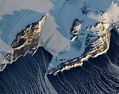
Just days away from the beginning of the Southern Hemisphere’s spring, Antarctica’s Inexpressible Island and the Northern Foothills Mountains were illuminated by a glimmer of sunlight from a low angle when the Advanced Land Imager (ALI) on NASA’s Earth Observing-1 (EO-1) satellite captured this image on September 16, 2009. The seaward slopes of the mountains are gleaming white, and they cast long shadows inland over the Nansen Ice Sheet. Terra Nova Bay appears in shadow.
The scene provides at least two indications of the bay’s persistent and fierce katabatic winds—downslope winds that blow from the interior of the ice sheet toward the coast. One is the windswept ground in the mountainous terrain. In many places, there is a pattern of bare rock and snow drifts that suggests the winds have scoured snow from upwind (inland-facing) slopes and deposited it on the lee sides.
The second sign of the strong winds appears in the open waters of Terra Nova Bay. Parallel white streamers are composed of newly formed sea ice, probably frazil—crystals just millimeters wide—and congealed frazil, called “grease ice” because it resembles an oil slick on the water. The ice is continually pushed out to sea by the strong offshore winds, leaving a pocket of open water, a polynya.


