Zermatt
 (c) Stan Shebs, CC BY-SA 3.0 Panorama miasta z widokiem na Matterhorn | |||
| |||
| Państwo | |||
|---|---|---|---|
| Kanton | |||
| SFOS | 6300 | ||
| Burmistrz | Christoph Bürgin | ||
| Powierzchnia | 242,67 km² | ||
| Wysokość | 1616 m n.p.m. | ||
| Populacja (2005) • liczba ludności • gęstość |
| ||
| Nr kierunkowy | 027 | ||
| Kod pocztowy | 3920 | ||
| Tablice rejestracyjne | VS | ||
Położenie na mapie Valais  | |||
Położenie na mapie Szwajcarii  (c) Karte: NordNordWest, Lizenz: Creative Commons by-sa-3.0 de | |||
| Strona internetowa | |||
Zermatt – miejscowość i gmina w Szwajcarii w kantonie Valais, położona w górnej części doliny Mattertal w Alpach Pennińskich, na wysokości 1616 m n.p.m. Leży u podnóża najwyższych szczytów Alp poza masywem Mont Blanc. Znajduje się tu 38 z 54 szczytów szwajcarskich powyżej 4000 metrów. Niektóre z najbardziej znanych to Dufourspitze w masywie Monte Rosa (4634 m), Dom (4545 m), Liskamm (4527 m), Weisshorn (4506 m) i Matterhorn (4478 m). Otaczają je duże lodowce takie jak Gornergletscher (drugi co do wielkości lodowiec Alp), Findelgletscher czy Zmuttgletscher[1][2].
Zermatt jest jedną z najpopularniejszych miejscowości wypoczynkowych w Szwajcarii. Jest też jednym z największych ośrodków sportów zimowych oraz wspinaczek górskich w tym kraju[3].
W mieście zabroniony jest ruch pojazdów spalinowych. Kursują po nim pojazdy elektryczne (przeważnie akumulatorowe) i dorożki konne. Do Zermatt nie prowadzi żadna ogólnodostępna i utwardzona droga. Duże parkingi samochodowe znajdują się w pobliskiej miejscowości Täsch[3]. Do Zermatt można dojechać elektryczną koleją zębatą kursującą na trasie Visp – Stalden – Täsch – Zermatt lub Glacier Expressem z St. Moritz i Davos do Zermatt[4]. Na wzgórzu nad miastem znajduje się duży heliport. Jest tu największa w regionie stacja ratownictwa górskiego[2].
W Zermatt znajduje się szereg kolejek linowych (m.in. najwyżej położona kolej linowa w Europie na Klein Matterhorn) oraz zębata kolej naziemna na Gornergrat[3][5].
Od Zermatt pochodzi nazwa zermatyzmu – antropologicznej pseudonauki stworzonej przez Stanisława Szukalskiego[6].
Galeria
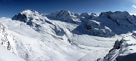
Masyw Monte Rosa
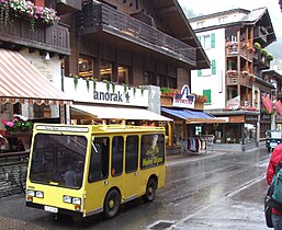
Elektryczny bus

Kolejka na Klein Matterhorn
Przypisy
- ↑ Wanderkarte, Zermatt – Cervinia (Breuil) – Täsch, Bundesamt der Landestopographie, 1998.
- ↑ a b Zermatt: Holidays in Switzerland & the Alps, „Zermatt, Switzerland” [dostęp 2018-07-16].
- ↑ a b c Wielka Encyklopedia Gór i Alpinizmu, tom 3, Góry Europy, Wydawnictwo STAPIS, Katowice, 2007, ISBN 978-83-60429-04-4.
- ↑ r, Narty. Szwajcaria – Zermatt [dostęp 2018-07-16] (pol.).
- ↑ Tips for Zermatt, the car free luxurious town in the Swiss Alps, www.myswissalps.com [dostęp 2018-07-16].
- ↑ Lechosław Lameński: Zermatyzm i Macimowa, czyli rozważania lingwistyczno-antropologiczne Szukalskiego. W: Lechosław Lameński: Stach z Warty Szukalski i Szczep Rogate Serce. Lublin: Wydawnictwo KUL, 2007, s. 239. ISBN 978-83-7363-554-8.
Linki zewnętrzne
Media użyte na tej stronie
(c) Karte: NordNordWest, Lizenz: Creative Commons by-sa-3.0 de
Location map of Switzerland


Flag of Canton of Valais (Switzerland). The black contours around the stars and along the division of the field are not usually seen in cantonal flags and are an artefact of this representation reflecting the image used for the pdf of the federal Fahnenreglement of 2007.

Autor: unknown, Licencja: CC-BY-SA-3.0
coat of arms city of Zermatt (Switzerland)

Autor: Tobi 87, Licencja: CC BY-SA 3.0
panoramic view from Gornergrat station (3110 m) in the ski-region Zermatt: on the left hand the Monte Rosa Massif with its Dufourspitze which is with its 4633,9 m the highest mountain in Switzerland and second highest mountain in the Alps and western Europe
(c) Stan Shebs, CC BY-SA 3.0
The Matterhorn is located on the border between Switzerland and Italy, towering over the Swiss town of Zermatt and the Italian town of Breuil-Cervinia in the Val Tournanche. It was the last major mountain of the Alps to be climbed, not merely because of its technical difficulty, but of the fear it inspired in early mountaineers. The first serious attempts began around 1858, mostly from the Italian side, but despite appearances, the southern routes are harder, and parties repeatedly found themselves on difficult slippery rock and had to turn back.
- A little touched up to reduce minor flaws and noise.

Autor: Claus Ableiter, Licencja: CC BY-SA 3.0
yellow electric vehicle in Zermatt, Switzerland

Autor:
- KleinMatterhorn.jpg: Cable1
- derivative work: Papa Lima Whiskey 2 (talk)
Klein Matterhorn, Zermatt
Autor: Abaddon1337, Licencja: CC BY-SA 3.0
Fork from media:Karte Kanton Wallis Bezirke 2010.png for geolocalisation