Zernez
 | |||
| |||
| Państwo | |||
|---|---|---|---|
| Kanton | |||
| Okręg | Engiadina Bassa/Val Müstair | ||
| SFOS | 3746 | ||
| Powierzchnia | 344,04 km² | ||
| Wysokość | 1 355 m n.p.m. | ||
| Populacja (31 grudnia 2020) • liczba ludności • gęstość |
| ||
| Nr kierunkowy | 081 | ||
| Kod pocztowy | 7530, 7542, 7543 | ||
| Tablice rejestracyjne | GR | ||
 | |||
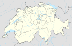
Położenie na mapie Szwajcarii (c) Karte: NordNordWest, Lizenz: Creative Commons by-sa-3.0 de | |||
| Strona internetowa | |||
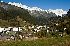
Zernez – gmina w Szwajcarii, w kantonie Gryzonia, w regionie Engiadina Bassa/Val Müstair. Ośrodek turystyczny i węzeł komunikacyjny. Zernez leży nad Innem. Siedziba władz Szwajcarskiego Parku Narodowego oraz zarządu firmy Engadiner Kraftwerke.
Demografia
W Zernez mieszka 1 506 osób[1]. W 2020 roku 19,3% populacji gminy stanowiły osoby urodzone poza Szwajcarią[1].
Transport
Przez teren gminy przebiegają drogi główne nr 27 i nr 28.
Przypisy
- ↑ a b c Bundesamt für Statistik, Ständige Wohnbevölkerung nach Staatsangehörigkeitskategorie, Geschlecht und Gemeinde, definitive Jahresergebnisse, 2020 - 2020 | Tabelle, Bundesamt für Statistik, 1 września 2021 [dostęp 2022-05-16] (niem.).
Media użyte na tej stronie
(c) Karte: NordNordWest, Lizenz: Creative Commons by-sa-3.0 de
Location map of Switzerland
Autor: This file was provided to Wikimedia Commons by Roland Zumbühl of Picswiss as part of a cooperation project. If the direct link to the picture is not provided (URLs are subject to changes), you can find the picture starting from the canton of the subject: http://www.picswiss.ch/geo.html then the location., Licencja: CC-BY-SA-3.0
Zernez in Switzerland. Left: Piz d'Urezza (2906). Piz dal Ras (3025). Background: Piz Murtera (3044) and Piz Chastè (2850). Muttas da Clüs (1684) behind church


