Ziemia Arnhema

Ziemia Arnhema – półwysep na północy Australii pomiędzy Morzem Timor, Morzem Arafura i Zatoką Karpentaria o powierzchni 425 000 km². Wybrzeża są dobrze rozwinięte z wieloma zatokami i wyspami przybrzeżnymi. Wnętrze wyżynne średnio 300–500 m n.p.m. Rzeki: Roper, Daly, Aligator. Większość półwyspu to sawanna, na wybrzeżach lasy podrównikowe, wzdłuż wybrzeży rosną namorzyny. Główne miasto i port to Darwin. Występują tu liczne złoża surowców mineralnych: rudy miedzi, uranu, boksytów oraz rudy wolframu.
Największy w Australii rezerwat Aborygenów leżący w Terytorium Północnym, założony w 1931, na wschód od miasta Darwin. Nazwa pochodzi od holenderskiego statku, który opłynął tę część wybrzeża w 1623. Początkowo przyjęta była dla północnej części Australii, ale od 1931 roku odnosi się tylko do rezerwatu. Powierzchnia wynosi ok. 97 tys. km², mieszka tam około 10 tys. osób. Większość ludności skupiona jest w strefie nadbrzeżnej. Na półwyspie Gove eksploatowane są boksyty. W rezerwacie znajdują się malowidła naskalne. Od 1972 znajduje się tam czynna huta aluminium. Od zachodu rezerwat graniczy z Parkiem Narodowym Kakadu.
Galeria

Wstęp na niektóre obszary, jest możliwy tylko za pozwoleniem Aborygenów
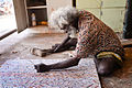
Aborygeński artysta mieszkający na półwyspie

Rzeka Goyder
Media użyte na tej stronie

Cape Arnhem is the extreme eastern tip of Arnhemland. Kakadu is over 260 miles away on the western border. billbeee 08:27, 20 May 2007 (UTC)

Autor: Glen Dillon, Licencja: CC BY-SA 3.0
Intersection of Central Arnhem Highway and the Goyder River, in Arnhem Land in the Northern Territory of Australia. Central Arnhem Highway runs from left to right across the photo. I was standing facing in a south-easterly direction at the time I took the photo, having just crossed the river in a Toyota Landcruiser whilst conducting a route survey for a proposed natural gas pipeline. The maximum depth of the river crossing was about 750mm (about 2.5'). Dry season (June 2000). Taken on standard film, developed and later scanned.

Autor: Glen Dillon, Licencja: CC BY-SA 3.0
A sign located in central Arnhem Land, in Australia's Northern Territory. To enter Arnhem Land requires permission from the Northern Land Council (a statutory authority representing the indigenous inhabitants of the northern half of the Territory). Parts of the region, as in the area behind this sign, are 'sacred' - ie they have significant cultural/historuical/religious significance to the indigenous owners, and are essentially "off limits" even to those with permission to travel across Arnhem Land.

Autor: Mark Roy from Jabiru, Australia, Licencja: CC BY 2.0
Arnhem Land artist Glen Namundja working on an artwork.
Przybliżone położenie Ziemia Arnhema