Credit:
Ten plik został umieszczony w Wikimedia Commons w ramach
współpracy z
Geographicus Rare Antique Maps, organizacją specjalizującą się w kartografii oraz handlu rzadkimi mapami antykwarycznymi wysokiej jakości powstałymi w okresie od XV do XIX wieku.
Wymiary:
4000 x 3029 Pixel (1537946 Bytes)
Opis:
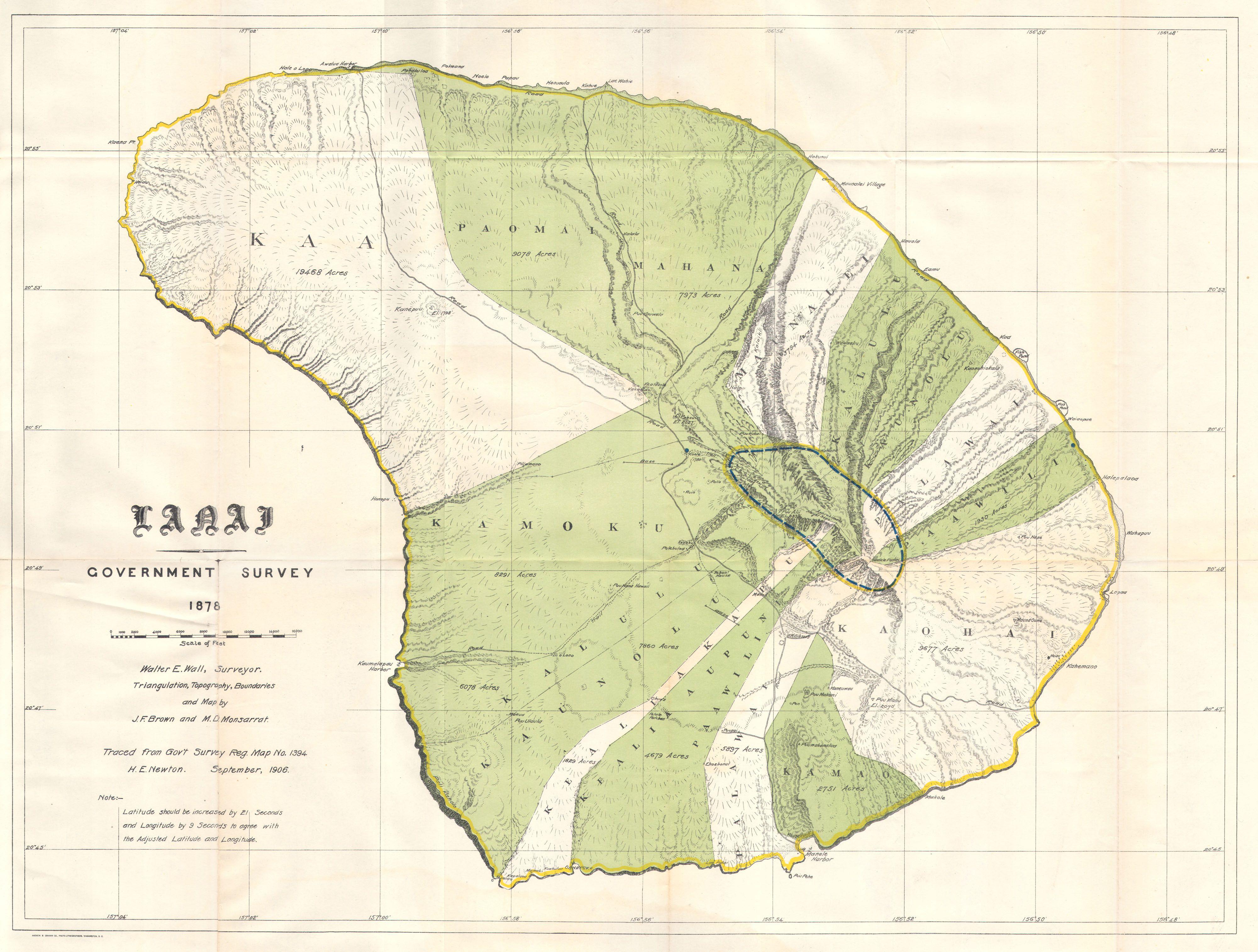
This rare and extraordinary 1878 map of the island of Lanai, in the Hawaiian group, was prepared for the 1906 Report of the Governor of the Territory of Hawaii to the Secretary of the Interior. Though the cartographic work that produced this map was started in 1878, during the Hawaiian Monarchy, the map itself, and the report that contained it, was issued following the U.S. Government’s 1898 annexation of the Hawaiian Republic. The Report was an attempt to assess and examine the newly created Hawaiian Territory’s potential for proper administration and development. Consequently the map focuses on Public Lands, Homestead Settlement Tracts, Grazing Lands, Pineapple Lands, Sugar Plantations, Forest Reserves, Forest Lands, Wet Lands, etc. It also features both practical and topographic details for use in administering the region. The governor at this time was George R. Carter. The primary triangulation for this map was accomplished by J. F. Brown and M. D Monsarrat. The survey work was done by Walter E. Wall. This map is heavily based upon the H. E Newton Government Survey Regional Map No. 1394.
Komentarz do licencji:
Plik jest wierną reprodukcją fotograficzną dwuwymiarowego utworu, znajdującego się w domenie publicznej z następującego powodu:
|
Public domainPublic domainfalsefalse
|
 |
Ten plik jest własnością publiczną w kraju pochodzenia oraz w państwach i na obszarach, gdzie prawo autorskie wygasa 70 lat po śmierci autora.
 You must also include a United States public domain tag to indicate why this work is in the public domain in the United States. Note that a few countries have copyright terms longer than 70 years: Mexico has 100 years, Jamaica has 95 years, Colombia has 80 years, and Guatemala and Samoa have 75 years. This image may not be in the public domain in these countries, which moreover do not implement the rule of the shorter term. Côte d'Ivoire has a general copyright term of 99 years and Honduras has 75 years, but they do implement the rule of the shorter term. Copyright may extend on works created by French who died for France in World War II (more information), Russians who served in the Eastern Front of World War II (known as the Great Patriotic War in Russia) and posthumously rehabilitated victims of Soviet repressions (more information). You must also include a United States public domain tag to indicate why this work is in the public domain in the United States. Note that a few countries have copyright terms longer than 70 years: Mexico has 100 years, Jamaica has 95 years, Colombia has 80 years, and Guatemala and Samoa have 75 years. This image may not be in the public domain in these countries, which moreover do not implement the rule of the shorter term. Côte d'Ivoire has a general copyright term of 99 years and Honduras has 75 years, but they do implement the rule of the shorter term. Copyright may extend on works created by French who died for France in World War II (more information), Russians who served in the Eastern Front of World War II (known as the Great Patriotic War in Russia) and posthumously rehabilitated victims of Soviet repressions (more information).
|
|
Plik rozpoznano jako wolny od znanych ograniczeń praw autorskich, włącznie z prawami zależnymi i pokrewnymi.
|
Zgodnie z oficjalnym oświadczeniem Wikimedia Foundation wierne reprodukcje dwuwymiarowych utworów z domeny publicznej są w domenie publicznej, zajmowanie przeciwnego stanowiska godzi w samą ideę domeny publicznej (więcej w: Commons:When to use the PD-Art tag).
Niniejsza reprodukcja jest więc również własnością publiczną.
Użytkowanie tego dzieła może być zabronione lub ograniczane przez miejscowe prawo na obszarze jego jurysdykcji; patrz: Commons:Reuse of PD-Art photographs. |