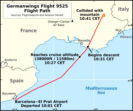
4U9525 flight path v1
Autor:
Attribution:
Obraz jest oznaczony jako „Wymagane uznanie autorstwa” (attribution required), ale nie podano żadnych informacji o uznaniu autorstwa. Prawdopodobnie parametr atrybucji został pominięty podczas korzystania z szablonu MediaWiki dla licencji CC-BY. Autorzy mogą znaleźć tutaj przykład prawidłowego korzystania z szablonów.
Credit:
Praca własna
Flight path based on data from Flightradar24, specifically the page for D-AIPX (only accessible for a limited time). Copyright can only be claimed for works which involve creativity and cannot be claimed on factual information. The data used for this map comes from the aircraft's transponders, which does not involve any human creativity and is factual information (position & altitude of the aircraft). Nonetheless, Flightradar24 is credited as the source of the information.
The crash symbol is positioned at the location of the crash according to the Aviation Herald: "The aircraft was found at approximate position N44.2979 E6.4670" (this is a short distance from the end of the data available from Flightradar24).
Background created from Natural Earth vector data (public domain).
Krótki link:
źródło:
Wymiary:
440 x 366 Pixel (176852 Bytes)
Opis:
Flight path of Germanwings Flight 9525 (English).
Licencja:
Komentarz do licencji:
Ja, właściciel praw autorskich do tego dzieła, udostępniam je na poniższej licencji
Warunki licencji:
Creative Commons Attribution 4.0
Więcej informacji o licencji można znaleźć tutaj. Ostatnia aktualizacja: Thu, 07 Jul 2022 15:30:25 GMT
