Aerial-GoletaArea
Autor:
John Wiley User:Jw4nvc - Santa Barbara, California
Attribution:
Obraz jest oznaczony jako „Wymagane uznanie autorstwa” (attribution required), ale nie podano żadnych informacji o uznaniu autorstwa. Prawdopodobnie parametr atrybucji został pominięty podczas korzystania z szablonu MediaWiki dla licencji CC-BY. Autorzy mogą znaleźć tutaj przykład prawidłowego korzystania z szablonów.
Credit:
Praca własna
Krótki link:
źródło:
Wymiary:
1024 x 413 Pixel (112120 Bytes)
Opis:
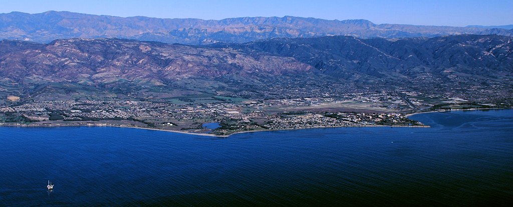
Aerial photo of the Goleta area, Santa Barbara County, California — from offshore.
- From the left: Ellwood area, Coal Oil Point and Devereux Slough area, Isla Vista and UCSB to Campus Point, Santa Barbara Airport behind Isla Vista and UCSB with residential Goleta up into the hillside beyond and downtown Goleta at the left edge directly beyond UCSB near Hwy.101 at the base of the hills, and on the shoreline beyond Campus Point is More Mesa. At the bottom left corner offshore is Oil Platform Holly.
- Santa Ynez Mountains are in backround.
Licencja:
Komentarz do licencji:
*For full details on Permissions for this user's work, see: User:Jw4nvc/permission/details
Warunki licencji:
Creative Commons Attribution 3.0
Więcej informacji o licencji można znaleźć tutaj. Ostatnia aktualizacja: Tue, 21 Sep 2021 02:13:58 GMT