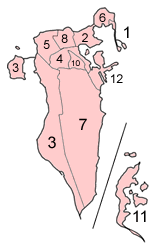
Bahrain municipalities numbered
Autor:
Attribution:
Obraz jest oznaczony jako „Wymagane uznanie autorstwa” (attribution required), ale nie podano żadnych informacji o uznaniu autorstwa. Prawdopodobnie parametr atrybucji został pominięty podczas korzystania z szablonu MediaWiki dla licencji CC-BY. Autorzy mogą znaleźć tutaj przykład prawidłowego korzystania z szablonów.
Credit:
Self-made, traced from public domain UN or CIA maps, with information from the Bahrain government.
Krótki link:
źródło:
Wymiary:
150 x 245 Pixel (7039 Bytes)
Opis:
Map of the municipalities of Bahrain (which existed until 2002), numbered in English alphabetical order (using a straight transliteration, rather than translation)
- Al Hadd
- Al Manamah (Manama)
- Al Mintaqah al Gharbiyah (Western)
- Al Mintaqah al Wusta (Central)
- Al Mintaqah al Shamaliyah (Northern)
- Al Muharraq
- Ar Rifa' wa al Mintaqah al Janubiyah (Rifa and Southern)
- Jidd Haffs
- Madinat Hamad (not on map; was created in 1991 and no proper reference material with it was found at the time this map was made)
- Madinat 'Isa
- Juzur Hawar (apparently entered out of order on the map)
- Sitrah
Licencja:
Warunki licencji:
Creative Commons Attribution-Share Alike 3.0
Więcej informacji o licencji można znaleźć tutaj. Ostatnia aktualizacja: Thu, 15 Sep 2022 23:24:44 GMT