Chernyakhov
Autor:
Attribution:
Obraz jest oznaczony jako „Wymagane uznanie autorstwa” (attribution required), ale nie podano żadnych informacji o uznaniu autorstwa. Prawdopodobnie parametr atrybucji został pominięty podczas korzystania z szablonu MediaWiki dla licencji CC-BY. Autorzy mogą znaleźć tutaj przykład prawidłowego korzystania z szablonów.
Krótki link:
źródło:
Wymiary:
777 x 471 Pixel (10065 Bytes)
Opis:
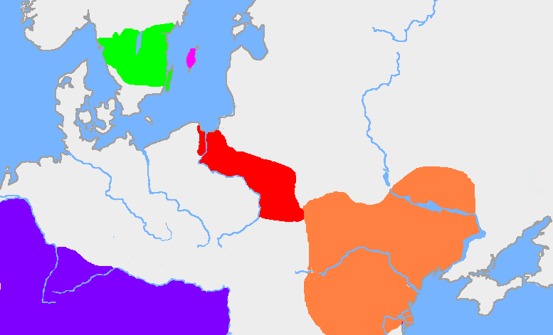
The green area is the traditional extent of Götaland and the pink area is the island of Gotland. The red area is the extent of the Wielbark culture in the early 3rd century, and the orange area is the Chernyakhov culture, in the early 4th century. The purple area is the Roman Empire.
The extent of the Wielbark culture is based on Zbigniew Babik: "Najstarsza warstwa nazewnicza na ziemiach polskich" Cracow 2001.
The extent of the Chernyakhov culture is based on R. Wołągiewicz (1993), a map drawn by Lars Östlin, in Kaliff's Gothic Connections. Contacts between eastern Scandinavia and the southern Baltic coast 1000 BC – 500 AD (2001:29)
Licencja:
Warunki licencji:
Creative Commons Attribution-Share Alike 3.0
Więcej informacji o licencji można znaleźć tutaj. Ostatnia aktualizacja: Thu, 01 Dec 2022 10:35:05 GMT