Corrientes-oceanicas
Autor:
Dr. Michael Pidwirny (see http://www.physicalgeography.net)
Credit:
Krótki link:
źródło:
Wymiary:
1000 x 522 Pixel (77005 Bytes)
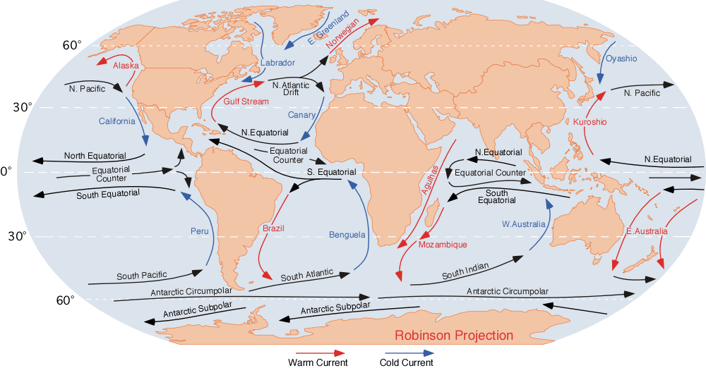
Opis:
Image of the ocean currents. Note that
- E. Greenland + Labrador + Norwegian = Viking gyre
- Gulf stream + N. Atlantic Drift + Canary + N. Equatorial = Columbus gyre
- S. Equatorial + Brazil + South Atlantic + Benguela = Navigator gyre
- S. Indian + S. Equatorial + Mozambique + W. Australia = Majid gyre
- Alaska + N. Pacific + Oyashio = Aloet gyre
- Kuroshio + N. Equatorial + California = Turtle gyre
- Peru + S. Pacific + E. Australia = Heyerdahl gyre
Finally, a few gyres also exist at the poles (not shown at this map); these are:
- North Pole: Polar bear gyre, Storkerson gyre, Melville gyre
- South Pole: Penguin gyre
Licencja:
Public domain
Komentarz do licencji:
Public domain. U.S. government publication.
Więcej informacji o licencji można znaleźć tutaj. Ostatnia aktualizacja: Sat, 20 Nov 2021 07:35:41 GMT