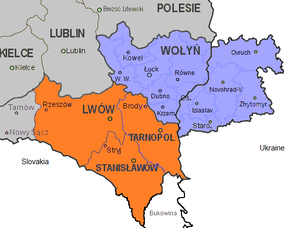
East Galicia and Volhynia 1939
Autor:
Credit:
Praca własna
Krótki link:
źródło:
Wymiary:
600 x 450 Pixel (76192 Bytes)
Opis:
Map of the south-eastern part of Poland, within the borders of 1921-1939, as well as the eastern part of Volhynia. Highlighted in orange colour are the three Polish voivodeships of Lwów, Stanisławów, and Tarnopol which form the eastern part of Galicia. Areas in grey are other Polish voivodeships. In blue the Polish voivodeship of Wołyń, with the black border separating the eastern part which was part of the Ukrainian Soviet Socialist Republic. Both parts form the historical region of Volhynia. The internal borders in blue in Volhynia are the old pre-war districts with their capital towns.
Abbreviations of towns in Volhynia:
W. W.: Włodzimierz Wołyński
Novohrad-V.: Novohrad-Volynskyi
Os.: Ostróg
Staro.: Starokostiantyniv
Licencja:
Warunki licencji:
Creative Commons Zero, Public Domain Dedication
Więcej informacji o licencji można znaleźć tutaj. Ostatnia aktualizacja: Sun, 25 Dec 2022 12:27:21 GMT