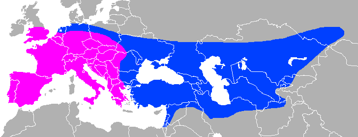
Neanderthal Range
Autor:
Praca własna
Attribution:
Obraz jest oznaczony jako „Wymagane uznanie autorstwa” (attribution required), ale nie podano żadnych informacji o uznaniu autorstwa. Prawdopodobnie parametr atrybucji został pominięty podczas korzystania z szablonu MediaWiki dla licencji CC-BY. Autorzy mogą znaleźć tutaj przykład prawidłowego korzystania z szablonów.
Credit:
Praca własna File:Mapa mundi blanco.PNG
Krótki link:
źródło:
Wymiary:
728 x 280 Pixel (13233 Bytes)
Opis:
Approximate Neanderthal range, with modern national borders for orientation.
Purple: pre-Neanderthal, early Neanderthal (450kya-130 kya), blue: classic Neanderthal, late Neanderthal (130kya-40kya).
Compromise between: File:Range of Neanderthals.png, File:Map of classic Neandertal fossil sites (hr-at).jpg, File:Map of pre-Neandertal fossil sites.jpg
.jpg)
Sicily is included because it was connected to the European mainland (as was Great Britain),
other Mediterranean islands are not included as there is no positive evidence that Neanderthals were present there, nor that they did cross any significant bodies of water.
Licencja:
Warunki licencji:
Creative Commons Attribution-Share Alike 4.0
Więcej informacji o licencji można znaleźć tutaj. Ostatnia aktualizacja: Sat, 19 Nov 2022 23:26:05 GMT