PeshtigoFireExtend
Autor:
US Census, Ruhrfisch
Credit:
derived from 2 sources:
- 1) Image:Wisconsin Locator Map.PNG , which was derived from United States

US Census website [1] and modified by User:Ruhrfisch
- 2) Redrew from photograph of a map of the extend on display at the en:Peshtigo Fire Museum.
Krótki link:
źródło:
Wymiary:
141 x 157 Pixel (3253 Bytes)
Opis:
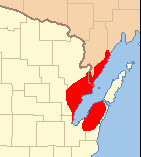
The extent of the October 8, 1871 en:Peshtigo Fire in red. The fire was the deadliest fire in the history of the United States. It consumed a large area surrounding en:Peshtigo, Wisconsin.
Licencja:
Public domain
Komentarz do licencji:
US Census / US Government work is public domain, my modifications licensed under the GNU Free Documentation License
Więcej informacji o licencji można znaleźć tutaj. Ostatnia aktualizacja: Wed, 07 Sep 2022 07:39:26 GMT