The start of the A601(M) - geograph.org.uk - 766525
Autor:
Credit:
From geograph.org.uk
Krótki link:
źródło:
_-_geograph.org.uk_-_766525.jpg?uselang=pl)
Wymiary:
640 x 426 Pixel (64174 Bytes)
Opis:
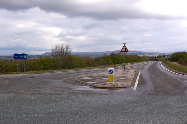
The start of the A601(M) The A601(M) has two parts - the part west of Junction 35 with the M6 is a dual carriageway link to the A6, and once formed the northern end of the M6 until the main motorway was extended northwards. But the eastern part was added in 1987 to enable lorries from the quarries to the south to join the M6 without having to go through Carnforth. Its potential usage didn't justify a full blown dual carriageway, but because it gave nowhere to go for non-motorway traffic, it had to be designated a motorway. The result: a stretch of single carriageway motorway, with two way traffic, which ends at a T junction with a B road (the B6254), as shown here! Note the motorway and two way traffic signs.
Not as impressive in length as what was the A6144(M) in Greater Manchester (SJ7793), which is also single carriageway but alas is now no longer a motorway, despite what the map for the square still shows (and unfortunately there are no photos of it on Geograph), but the A601(M) is still a worthy feature of the UK road network. In particular, being a motorway without speed limit indications, it presumably has a 70mph speed limit - one of the few places in the country where one can legally travel at 70mph on a non-dual carriageway, not that the stretch of road is really long enough to allow it!
Licencja:
Warunki licencji:
Creative Commons Attribution-Share Alike 2.0
Więcej informacji o licencji można znaleźć tutaj. Ostatnia aktualizacja: Mon, 09 Aug 2021 00:10:58 GMT