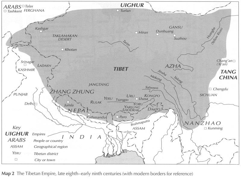
Tibetan empire greatest extent 780s-790s CE

Autor:
Attribution:
Obraz jest oznaczony jako „Wymagane uznanie autorstwa” (attribution required), ale nie podano żadnych informacji o uznaniu autorstwa. Prawdopodobnie parametr atrybucji został pominięty podczas korzystania z szablonu MediaWiki dla licencji CC-BY. Autorzy mogą znaleźć tutaj przykład prawidłowego korzystania z szablonów.
Credit:
Praca własna
Krótki link:
źródło:
Wymiary:
1792 x 1361 Pixel (4775168 Bytes)
Opis:
Map of the Tibetan Empire at its greatest extent between the 780s and the 790s CE
sources:
- Kapstein, Matthew T. (2006) "The Tibetan Empire, late eighth-early ninth centuries" in The Tibetans, Chichester, West Sussex: Wiley-Blackwell, s. XX ISBN: 978-0-631-22574-4.
- http://unitednations4freetibet.com/unfft/wp-content/uploads/2010/11/The-Nation-of-Tibet.pdf
- http://sitemaker.umich.edu/mladjov/files/china800.jpg
- http://www.lib.utexas.edu/maps/middle_east_and_asia/china_map_folio/txu-oclc-588534-54930-10-67-map.jpg
- The Silk Road: trade, travel, war and faith by Susan Whitfield, British Library
- http://www.tew.org/geography/historical.map1.html
- http://qed.princeton.edu/getfile.php?f=The_Chinese_world,_7th-8th_centuries.jpg
- http://pages.uoregon.edu/kimball/images/1294.ASA-CWA153.jpg
Licencja:
Warunki licencji:
Creative Commons Attribution 3.0
Więcej informacji o licencji można znaleźć tutaj. Ostatnia aktualizacja: Fri, 04 Nov 2022 18:05:57 GMT